Poor, building surf, cleaning up while easing through mid-late next week
Western Australian Surf Forecast by Craig Brokensha (issued Friday September 29th)
Best Days: Perth and Mandurah Tuesday morning, Wednesday morning, Thursday morning, Friday
Features of the Forecast (tl;dr)
- Moderate sized + mid-period W/SW swell building Sat with strong W/SW winds, easing
- Strengthening W/NW-NW winds Sun with a building, stormy windswell
- XL, stormy swell building Mon with strong W/SW tending SW winds
- Peak in XL groundswell Tue AM, easing through the day
- Mod-fesh S/SW winds Tue (S/SE to the north in the AM)
- Large, easing surf Wed with E/NE winds ahead of sea breezes
- Large S/SW groundswell building Thu PM with E/SE tending S/SW winds
- Easing S/SW groundswell Fri with E/NE tending variable winds
Recap
Winds shifted to the south yesterday with large, easing surf from 6-8ft across the South West, 3ft in Mandurah and 2-3ft across Perth yesterday morning, smaller today with slightly cleaner conditions under lighter winds.
Conditions will deteriorate through the day today as an approaching front brings increasing W'ly winds.
This weekend and next week (Sep 30 – Oct 6)
The weekend will be a write-off thanks to a mid-latitude front ahead of a much more significant frontal progression moves in, bringing strong W/SW winds in the morning, easing into the afternoon. Some new moderate sized mid-period W/SW swell is due from this front for the afternoon but there'll be nowhere to recommend for a surf.
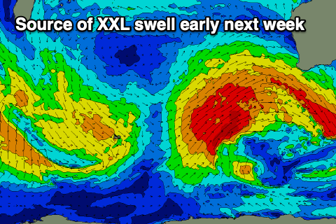
Sunday will see strengthening W/NW winds and building levels of stormy swell as the head of the slow moving Southern Ocean frontal progression starts to edge in.
This progression is quite significant with a slow moving fetch of gales due to to strengthen and reach severe-gale in patches while projecting slowly east-northeast.

An extra-large W/SW-SW groundswell will be generated with it building through Monday along with some stormy windswell, peaking Tuesday morning. Strong W/SW-SW winds will create poor conditions Monday while the progression will move east on Tuesday allowing winds to abate and shift S/SW (moderate to fresh in strength). Perth and Mandurah are likely to see morning S/SE winds and size wise the South West looks to be 15ft later Monday and Tuesday morning, with Mandurah easing from 4-5ft+ with 3-4ft surf in Perth.
Wednesday will become smaller but still be solid and with great E-E/NE offshore winds through the morning. The South West looks to still be 8ft, 3ft across Mandurah and 2ft+ in Perth.
Our reinforcing pulse of large S/SW groundswell for Thursday/Friday is on track with a strong polar low expected to fire up late in our swell window Monday.

It's forecast to generate a significant fetch of severe-gale W/NW-NW winds, reaching storm force but east of our swell window.
The groundswell will favour the South West, building rapidly Thursday and peaking later to 8ft with Mandurah seeing 2ft to possibly 3ft sets, 2ft across Mandurah, easing Friday.
Winds look great Thursday morning and E/SE ahead of afternoon sea breezes, E/NE tending variable Friday as the swell eases. Following this the outlook is slower so make the most of the improving surf next week.
Have a great weekend!

