Easing surf from tomorrow as onshore winds persist in the South West
Western Australian Surf Forecast by Craig Brokensha (issued Monday August 21st)
Best Days: This afternoon for the keen, Perth and Mandurah tomorrow morning and Wednesday morning, Margs Thursday morning and Friday on the magnets
Features of the Forecast (tl;dr)
- Large SW groundswell for today, peaking overnight, easing tomorrow
- Reinforcing SW groundswell for Wed AM, easing into Thu/Fri and the weekend
- Moderate W winds tomorrow, light E/NE to the north, similar Wed
- Variable winds ahead of weak sea breezes Thu (light offshore to the north)
- E/NE tending light NW winds Fri with easing surf
- Smaller Sat with NE tending NW winds, fresh W Sun
- Small-mod sized SW groundswell building Mon with E tending W winds
Recap
Smaller surf with lingering onshore winds across the South West Saturday, cleaner to the north but only to 2ft in Mandurah, tiny across Perth.
Sunday saw a new pulse of mid-period SW swell which maintained 2ft sets across Mandurah with 1-1.5ft waves in Perth as strong onshore winds kicked back in across Margs.
Today we've got larger, building surf with a period of S'ly winds in the morning that are now SW though without too much strength, 3ft and clean across Mandurah and 2-3ft in Perth.

Large, lumpy surf this afternoon
This week and weekend (Aug 22 - 27)
The coming days look to remain average for the South West as persistent frontal activity sees unfavourable W'ly winds that only look to back off later week when the size is done.
Today's large, building SW groundswell is due to start easing through tomorrow but with moderate W'ly winds lingering in the South West, light E/NE to the north along with easing sets from 8-10ft in the South West, 3ft+ Mandurah and 2-3ft in Perth.
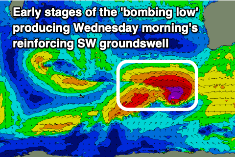
Wednesday should see a reinforcing SW groundswell peaking across the South West in the morning, generated by pre-frontal severe-gale W/NW winds at the head of a rapidly deepening low pressure system to the south of us.
This will actually be a 'bombing low' dropping well over 24hPa within 24 hours, but only forming late in our swell window.

Either way, W'ly winds will persist Wednesday with strong sets to 6-8ft, easing through the day, 2ft+ across Mandurah and 2ft in Perth under morning E/NE winds.
Come Thursday we may see more variable winds develop across the South West but with smaller, easing sets from 4-6ft, 1-2ft Mandurah and 1-1.5ft Perth.
Friday looks smaller again and with E/NE tending weak onshore winds.
Unfortunately the weekend doesn't hold any more hope for a surf with the swell due to bottom out, clean early Saturday before winds go onshore from the NW and then fresher W on Sunday as a small, weak trough moves in from the west.
We should see this trough dissolve through early next week, bringing offshore winds and cleaner conditions along with a fun new pulse of S/SW groundswell. The source will be a strong polar front generating gale to severe-gale W/NW winds while tracking east-southeast through our swell window which isn't ideal. Still we should see a good pulse of size for Monday, building to 4-6ft across the South West with smaller 1-2ft waves in Mandurah.
Following this the outlook is very slow with the Southern Ocean going quite for the start of spring. More on this Wednesday.

