Good swells with tricky winds for the South West but mostly light
Western Australian Surf Forecast by Craig Brokensha (issued Friday July 18th)
Best Days: Tomorrow morning, Sunday morning Perth and Mandurah, Monday all locations, Tuesday, Wednesday and Thursday mornings
Features of the Forecast (tl;dr)
- Smaller, easing surf Sat with variable winds ahead of sea breezes, light E to the north
- New moderate sized + SW groundswell Sun with strengthening W/NW winds in the South West, light E/NE-NE to the north in the AM
- Large SW groundswell building Mon PM, peaking later with S/SE-SE tending W/SW winds, easing Tue with variable winds increasing from the W (light E to the north)
- Reinforcing SW groundswell Wed with variable winds in the South West ahead of sea breezes, light E to the north
Recap
Perth and Mandurah offered good, lumpy waves to 2-3ft yesterday morning, becoming bumpy into the afternoon but not deteriorating too adversely. Today conditions are cleaner in Perth and Mandurah with a new pulse of SW swell yesterday afternoon maintaining 2-3ft sets in Mandurah and 2ft across Perth. Margs was bumpy and average but has improved as the day has gone on.
This weekend and next week (Jun 19 - 25)
Looking at the weekend ahead we should see the current swell continuing to ease and winds should be more variable across the South West but the size will be down and easing from 4-5ft, 2ft max on the sets in Mandurah and 1-2ft across Perth.
Winds will freshen from the W/NW through the day and then we’ll be looking at stronger W’ly winds developing Sunday (E/NE-NE to the north), therefore make the most of early tomorrow’s window if you’re keen for a paddle.
The increasing W/NW winds will be linked to a couple of back to pre-frontal fetches of strong to gale-force W/NW winds glancing our swell window, with the first generating a new pulse of mid-period SW swell for Sunday. Perth and Mandurah aren't expected to see much size with 2ft waves continuing across the latter, 1-2ft in the former.

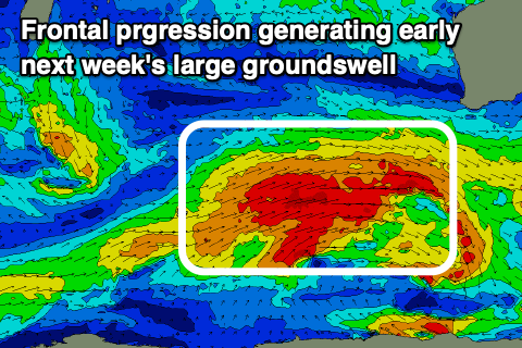
Our larger SW groundswell for Monday from a more significant Southern Ocean frontal progression is on track but with a slight downgrade in size from Wednesday.
We're looking at a healthy, slow moving fetch of W/SW gales developing over the coming days to our south-west, with building surf to the 10ft range due in the South West Monday afternoon, easing from a similar size Tuesday morning. Mandurah looks to reach 3ft+, with 2-3ft sets in Perth.
Local winds on Monday look S/SE across the South West and SE to the north through the morning, giving into weak afternoon sea breezes, with Tuesday looking dicey across the South West as light to moderate W'ly winds linger. We may see variable breezes but I'll confirm this on Monday. Perth and Mandurah look great with offshore, E/NE winds.
Wednesday looks to play out similar to Tuesday wind wise along with a reinforcing pulse of SW groundswell.

The source will be a final low firing up on the tail of the Southern Ocean frontal progression, generating a fetch of severe-gale W/NW winds late in our swell window.
The South West should maintain 8ft+ sets, 2-3ft across Mandurah and 2ft in Perth.
We'll then see improving conditions with easing surf into the end of the week, with the next swell possibly arriving late week. More on this Monday, have a great weekend!


Comments
'Winds will freshen from the W/NW through the day and then we’ll be looking at stronger W’ly winds developing Sunday (E/NE-NE to the north), therefore make the most of early tomorrow’s window if you’re keen for a paddle.'
ENE-NE to the north on SUN or SAT?