Large swells this week with varying winds
Western Australia Surf Forecast by Craig Brokensha (issued Monday August 14th)
Best Days: Wednesday morning protected spots, Perth and Mandurah Thursday morning, Friday and Saturday mornings all locations
Features of the Forecast (tl;dr)
- Large SW groundswell building Tue, easing Wed, with a secondary more consistent pulse building Thu PM, easing Fri
- Strong W/NW winds tomorrow
- Moderate S/SE-SE tending S/SW-SW winds Wed
- Mod to fresh SW winds in the South West Thu, lighter E/NE-NE to the north
- Light S/SE-S winds in the South West Fri AM, light E to the north
- Easing surf Sat with variable offshore winds ahead of sea breezes
- Increasing W winds Sun with building surf
- Oversized SW groundswell Mon with SW winds
Recap
Great conditions Saturday and Sunday morning across the South West with a building swell through the former, holding into the latter.
Perth and Mandurah also offered fun surf, 2ft on Saturday and 2-3ft Sunday to the south and 1-1.5ft and 2ft respectively across Perth.
Today the swell has reached a low point with strengthening onshore winds in the South West which are now impacting more metro locations.

Building swell with light winds Saturday PM
This week and weekend (Aug 15 - 20)
Looking at the week ahead we've got our two, large back to back groundswells due with a window of semi-decent (lumpy) conditions due across the South West mid-week but otherwise average.
The first and largest groundswell for tomorrow has been generated by the strong and persistent polar frontal progression that formed south of South Africa last week.
Initial severe-gale W/NW winds were generated in our far swell window with the progression since weakening while tracking east and then breaking down on approach to us today.

This is the cause of today's onshore winds, with strong W/NW winds due across all locations tomorrow morning, shifting S/SE after dark as the front clears temporarily to the east.
We can expect the large groundswell to build through the day and peak into the afternoon with the surf reaching 10ft+ in the South West, 3ft across Mandurah and 2-3ft in Perth.
The surf then looks to ease back through Wednesday from 10ft, 3ft and 2-3ft respectively with a window of moderate S/SE-SE winds before reverting back to the S/SW-SW into the afternoon while freshening.
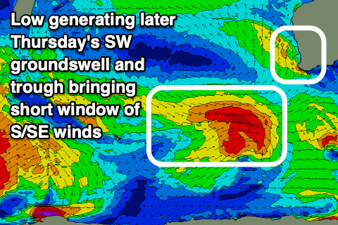
This will be thanks to a trough clipping us, ahead of the next swell producing low bringing persistent, moderate to fresh SW winds to the South West with lighter E/NE-NE winds to the north Thursday.
The low is forecast to generate a good fetch of W/NW gales while moving through our swell window over the coming days, producing a reinforcing SW groundswell for Thursday afternoon/evening.

The South West should build back to 8-10ft while Perth and Mandurah look to maintain 2ft surf, with easing sets from 2ft+ Friday morning as the South West eases from the 8ft range.
Lighter offshore winds are due across Perth and Mandurah Friday morning, variable S/SE-S in the South West, shifting W/SW through the day.
Sunday morning could be nice and clean with light E/NE-NE winds as the swell continues to ease.
The next frontal progression looks to move in Sunday bringing a return to onshore winds and what looks to be a more significant, oversized SW groundswell but we'll have a closer look at this on Wednesday.


Comments
Thanks Craig, just as an FYI, as the local Mandurah surf report today stated “it’s highly advisable to stay clear of the water around the Falcon and Halls Head areas due to a large decomposing whale that washed ashore yesterday.”
Thanks Trev!