Fun weekend of surf ahead
Western Australia Surf Forecast by Craig Brokensha (issued Friday August 11th)
Best Days: This morning, tomorrow, Sunday morning, early Monday Perth and Mandurah, Wednesday morning protected spots, Thursday and Friday mornings Perth and Mandurah
Features of the Forecast (tl;dr)
- Mod-large S/SW swell for Sat, with a reinforcing pulse Sun AM, easing
- Mod-fresh E/SE tending variable winds Sat, E/NE tending N/N-NW winds Sun, freshening in the South West from the W/NW later
- Strengthening W/NW winds Mon (N/NE early Perth and Mandurah), fresh to strong NW winds Tue, tending S/SW late in the south
- Large SW groundswell building Tue, easing Wed, with a secondary more consistent pulse building Thu PM, easing Fri
- Gusty S/SE tending S/SW-SW winds Wed
- Fresh W/SW winds in the South West Thu, lighter Fri (light offshore to the north each morning)
Recap
A fun day of waves across all locations yesterday with surf to 6ft with offshore winds in the South West, 2-3ft in Perth and Mandurah.
Today we've got a little less swell with clean conditions across most spots, a little lumpy in the South West as winds go a little more south of east.
This weekend and next week (Aug 12 - 18)
The weekend ahead looks fun with a renewal of S/SW swell energy with favourable conditions tomorrow and Sunday morning.
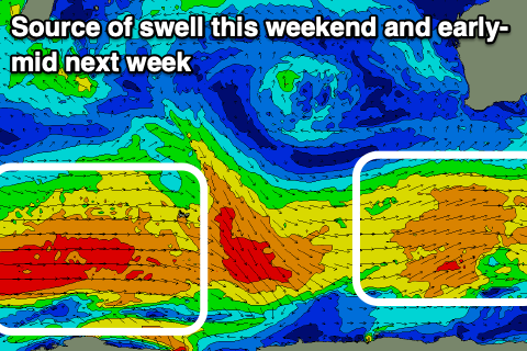
The source of the energy was a healthy but generally weak polar frontal progression to our south-west and south since mid-week.
We should see the swell build through the day, peaking into the afternoon, with a secondary pulse of reinforcing energy due to maintain similar sized waves Sunday morning.
Building surf to 6ft+ is due across the South West, with 2ft waves in Mandurah and 1-2ft sets in Perth, holding Sunday morning, easing into the afternoon.

A moderate to fresh E/SE winds will create clean conditions tomorrow morning, tending variable into the afternoon with Sunday seeing morning E/NE winds, shifting N/NW-NW through the day and then W/NW into the afternoon (fresh across the South West).
This should provide plenty of time for a few surfs on the weekend if yo've got the stamina.
Moving into Monday an approaching polar front will bring strengthening W/NW winds (N/NE-NE early Perth and Mandurah but small).
The earlier stages of this frontal system, that being a strong progression to the south of South Africa which formed yesterday, pushing east while generating weakening gale to severe-gale winds, will generate a large SW groundswell for Tuesday, peaking into the late afternoon and easing Wednesday.
Unfortunately fresh to strong NW winds will spoil this swell as it builds, with a late S/SW change possibly opening up options for the desperate in the South West through the evening.
Size wise the South West should come in at 10ft+ Tuesday afternoon, 3ft across Mandurah and 2-3ft on Perth, easing from a similar size Wednesday.
Winds may tend temporarily S/SE on Wednesday morning, but then quickly revert back to the S/SW-SW with the next approaching storm.
This will be a strong polar low projecting up towards us, generating a fetch of gale to severe-gale W'ly tending SW winds.
A large, strong SW groundswell is due from this low arriving Thursday and building strongly into the afternoon to 10ft+ across the South West, 3ft Mandurah and 2-3ft in Perth again.
Winds unfortunately look to remain onshore Thursday across the South West, out of the W/SW with N/NE winds to the north, with lighter, lingering W winds Friday.
The weekend looks cleaner across the South West but with small, leftover surf. We'll confirm this Monday, have a great weekend!

