Better run of conditions with good swell pulses
Western Australia Surf Forecast by Craig Brokensha (issued Friday August 4th)
Best Days: Today, tomorrow, Sunday, early Monday, Wednesday, Thursday morning
Features of the Forecast (tl;dr)
- Easing surf tomorrow with E/NE-NE tending variable N/NE winds
- Large S/SW groundswell building later tomorrow, peaking Sun with E/SE winds ahead of weak sea breezes
- Reinforcing mod-large mid-period W/SW swell for Mon PM, easing Tue
- Early E/NE-NE tending fresh N/NW winds Mon, strong W/NW Tue
- Mod-large mid-period W/SW swell Wed with E tending variable winds
- Easing swell Thu with E tending SW winds
Recap
Wednesday afternoon's pulse of oversized sized swell held into yesterday morning with 12ft+ waves across the South West with favourable conditions for protected spots, 4ft across Mandurah and 3ft in Perth. Perth was still a bit raw and best in protected spots.
Today conditions are excellent across most locations with the South West easing back from 8ft while Perth and Mandurah were still an easy 3ft. The surf will continue to ease through the day as winds go variable to the north and light N/NW in the South West.

:o

Decent conditions with a bit of size left in the mix
This weekend and next week (Aug 5 - 11)
Tomorrow looks temporarily smaller in the South West ahead of a new pulse of S/SW groundswell later in the day but more so Sunday, generated by a healthy polar low that's currently south-southwest of us.
It's been upgraded a little in strength with core wind speeds hitting storm-force though it was mostly gale to severe-gale.

This should produce a large spike in swell Sunday morning to 8ft+ across the South West, easing back through the day with 2-3ft sets in Mandurah and 2ft across Perth.
Winds tomorrow morning will be favourable and moderate from the E/NE-NE, tending N/NE through the day and then easing. This will favour a late surf tomorrow in the South West with the new swell likely to hit 6ft+ by dark.
Sunday should offer great conditions with a light E/SE offshore wind across most spots ahead of afternoon S/SW sea breezes.
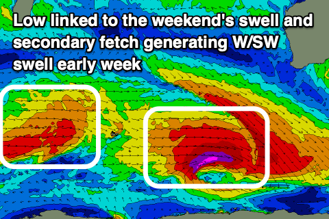
Into Monday, a reinforcing pulse of mid-period W/SW swell looks to provide similar sized waves across Perth and Mandurah, with the South West coming in a little smaller and to 6-8ft, generated by a healthy but weaker frontal system that's currently moving through the southern Indian Ocean.
The swell is due to fill in Monday and then ease Tuesday with clean conditions early Monday, deteriorating through the day with freshening N/NW winds, stronger W/NW across all locations Tuesday, creating poor surf.
This will be linked to a relatively weak mid-latitude frontal progression pushing up and into us.
No major size is due off this progression with surf likely continuing in the 6-8ft range across the South West, 2-3ft Mandurah and 2ft across Perth for Wednesday as the front clears to the east.
Winds look to swing offshore creating clean conditions with easing surf into the end of the week with morning offshores.
Longer term some larger groundswell is on the cards for early next week with onshore winds as it builds cleaner as it eases. We'll take a closer look at this on Monday though. Have a great weekend!


Comments