A few better windows for surf in the South West
Western Australia Surf Forecast by Craig Brokensha (issued Monday July 31st)
Best Days: Today all locations, tomorrow morning Perth and Mandurah, Thursday all locations, Friday all locations, Saturday, Sunday (morning in the South West)
Features of the Forecast (tl;dr)
- Easing surf tomorrow with strong N/NW winds (fresh N/NE early to the north)
- Oversized SW groundswell building Wed with strong N/NW tending S/SW winds
- Easing oversized swell Thu with E/SE tending variable winds to the north, S/SE-SE in the south
- Easing surf Fri with N/NE-NE tending NW winds, E/NE tending NW to the north
- Large SW groundswell building Sat, peaking in the PM with NE tending variable winds
- Easing swell Sun with NE tending NW winds
Recap
Poor conditions across the South West on the weekend, biggest yesterday with weaker onshore winds.
Mandurah and Perth were both choppy and onshore Saturday and to 3ft, cleaner yesterday with lumpy but good sized surf holding the 3ft range.
Today the surf is on the ease after peaking through yesterday with lumpy 8ft+ waves in the South West, clean and 2-3ft in Mandurah and Perth.
Strong sets this morning
This week and weekend (Aug 1 - 6)
Make the most of the favourable conditions across the South West today as we'll see strong N/NW winds kick in from dawn tomorrow along with a further drop in swell from today.
Perth and Mandurah should be 2ft or so and with early N/NE-NE winds, shifting N/NW through the day.
Moving into Wednesday we're expected to see a trough bringing a strong S/SW change, with it impacting Margs first, then moving north through the day with those strong N/NW winds ahead of it.
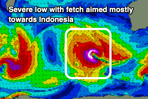
This trough will originate from a severe low that's between us and Heard Island, generating a significant fetch of severe-gale to storm-force S/SW winds, aimed mostly towards Indonesia.

The low will move slowly east while expanding and consequently slowly weakening, with an oversized, long-period SW groundswell due to emanate out, arriving Wednesday and building strongly to a peak late afternoon/evening before easing Thursday.
Building sets to 12ft are due late across the South West, easing back from a similar size on Thursday, with Mandurah easing back from 3-4ft and Perth 3ft. We'll have to check these sizes on Wednesday as EC has the low a touch weaker and not as broad as GFS.
With the trough clearing to the east we're due to see winds swing around to the E/SE on Thursday morning across Perth and Mandurah, S/SE-SE in the South West ahead of variable sea breezes.
Friday will become smaller and winds will tend more E/NE to the north with N/NE-NE winds in Margs, tending NW into the afternoon and freshening a little.
The next increase in swell looks to arrive out of the SW on the weekend, generated by a strong polar low firing up just east of the Heard Island region Wednesday evening.
A great fetch of severe-gale to storm-force W/SW winds should generate a large SW groundswell that will build rapidly Saturday, reaching 8ft across the South West, 2-3ft in Mandurah and 2ft across Perth.
Winds on Saturday look to hold from the north-eastern quadrant, tending variable into the afternoon with Sunday seeing similar morning winds, shifting NW into the afternoon.
Longer term, weaker, mid-latitude fronts/lows look to bring weaker swells and average winds next week but we'll look at this in more detail on Wednesday.


