Large surf developing on the weekend, best in the South West Monday
Western Australia Surf Forecast by Craig Brokensha (issued Friday July 28th)
Best Days: Perth and Mandurah Sunday morning, Monday (morning in the South West), early Tuesday Perth/Mandurah, Thursday and Friday
Features of the Forecast (tl;dr)
- Large mid-period W/SW-SW swell tomorrow with strong but slowly easing W/SW winds
- Larger mix of SW swells Sunday with moderate W/SW winds in the South West (E/NE-NE to the north in the AM)
- Large, easing SW swell Mon with variable tending N/NW winds (E/NE-NE in the AM)
- Smaller Tue with strong N/NW winds in the South West, NE in the AM to the north
- Oversized SW groundswell building Wed with strong N/NW tending S/SW winds
- Easing swell Thu with S/SE-SE winds
- Small Fri with morning E/NE winds
Recap
Nothing of any real quality through yesterday with Mandurah fairing best wind wise with lumpy, 3ft+ waves in protected spots.
Today the swell is smaller and conditions are poor across all locations as a small front ahead of a stronger frontal progression clips us.
This weekend and next week (Jul 20 – Aug 4)
Mid-period W/SW-SW swell energy is due tomorrow across all locations in the large size range but with strong but slowly abating W/SW winds into the late afternoon.
Sunday will see weaker, moderate W/SW winds in the South West and light E/NE-NE offshores to the north along with a large pulse of new mid-period SW swell, with some stronger groundswell due later in the day, easing Monday.
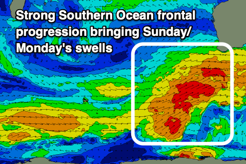
The source of mixed groundswell and mid-period energy were and are still being generated by a strong, persistent frontal progression that spawned under South Africa early in the week and has since traversed to a positioned south-west of us.

The progression is weakening but still projecting fetches of strong to gale-force SW winds up and into and then under us.
This will produce a large mix of swells with the mid-period energy peaking Sunday morning ahead of the less consistent groundswell later in the day, with both easing slowly Monday.
The South West should see surf to 10-12ft Sunday with 3-4ft waves in Mandurah and 3ft across Perth, easing back Monday from 10ft, 3ft and 2-3ft respectively.
Winds are still expected to become light and variable across the South West into Monday with a light, morning E/NE-NE breeze, though expect a lot of lump and rawness. Conditions will become bumpy into the afternoon with a N/NW breeze.
As touched on in Wednesday's update, the window for decent conditions in the South West is slim, with strengthening N/NW winds due to kick in from early Tuesday (NE to the north along with a further drop in size).

These strengthening N/NW winds will be ahead of a significant but funky low forming between us and the Heard Island region, though aimed more towards Indonesia than anything. The low is due to weaken while expanding north on approach to us through Tuesday, with a north/south aligned trough impacting us on Wednesday.
An oversized SW groundswell is due Wednesday from storm-force winds around the core of the low but with strong NW tending S/SW winds, possibly tending S/SE-SE on Thursday as the trough clears east and the swell eases. Friday looks clean with moderate-large easing surf but we'll have a closer look at this on Monday. Have a great weekend!

