One window to target in the south
Western Australia Surf Forecast by Craig Brokensha (issued Wednesday July 26th)
Best Days: Perth and Mandurah tomorrow morning and Sunday morning, all locations Monday, Perth and Mandurah early Tuesday
Features of the Forecast (tl;dr)
- Large close-range SW swell for tomorrow, easing with strong S/SW tending SW and W/SW winds in the South West (S/SE-SE early to the north)
- Strong W/NW winds Fri with a building mid-period W/SW swell, persisting Sat with strong W winds
- Large and extra-large mix of SW swells building later Sat but more so Sun (peaking late) with light to moderate W winds (variable to the north early)
- Easing swell Mon with variable E/NE-NE winds ahead of weak sea breezes
- Smaller Tue with strengthening N/NW winds (N/NE early to the north)
Recap
Early N/NE winds provided a window of clean conditions across the Perth and Mandurah regions before deteriorating through the day. Margs was poor, choppy and onshore.
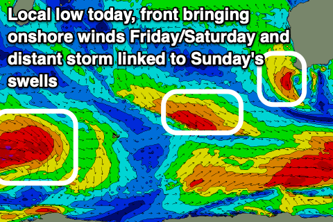
Today conditions were poor across most locations, with a window of lighter winds in Mandurah. The trough bringing the onshore winds today has formed a small low pressure centre and with it, building SW swell across the South West.
This week and next (Jul 27 – Aug 4)
Onshore, that's the continuing theme for the South West for the coming period, with Monday next week being the only real window for a surf.
The low that's sitting off our south-west today will move east tomorrow resulting in large easing surf with strong S/SW tending SW and then W/SW winds ahead of the next frontal system.
Perth and Mandurah should see early S/SE winds along with easing 3ft and 3-4ft waves respectively.
Strong WNW winds will kick in across all locations on Friday along with a large, building mid-period W/SW swell, though to no major size, holding Saturday as winds also persist out of the W.
Of greater significance is a strong Southern Ocean frontal progression that's currently developed to the south of South Africa.

This polar front is due to swing in along the polar shelf, generating a fetch of gale to severe-gale W'ly winds, weakening a touch while approaching us over the coming days. A secondary surf of gales on the backside of the progression during Friday and Saturday should help boost wave heights on top of an already large groundswell, with building surf due later Saturday ahead of a peak Sunday afternoon, easing slowly Monday.
The South West should peak in the 12-15ft range later Sunday, easing from 12ft+ Monday with 4-5ft sets in Mandurah, 3-4ft across Perth later Sunday, easing from 4ft+ and 3-4ft respectively Monday morning.
What we're most interested in are the local winds and Sunday will see lighter, onshore W/SW breezes (offshore across Perth and Mandurah in the morning), with variable offshore E/NE-NE winds across all locations Monday morning ahead of weak sea breezes.
This window looks small with onshore breezes due to kick back in from the N/NW Tuesday but we'll review this on Friday.
Longer term, large windy surf looks to develop into the middle to end of the week but the models diverge in what form. More on this Friday.

