Large swells with winds from the north-eastern quadrant
Western Australia Surf Forecast by Craig Brokensha (issued Friday July 21st)
Best Days: Tomorrow, Sunday, Monday and Tuesday selected spots
Features of the Forecast (tl;dr)
- Large mid-period W/SW swell for later today, easing tomorrow
- E/NE-NE tending light NW winds in the South West tomorrow, variable to the north
- Oversized long-period W/SW groundswell building Sun PM, peaking overnight, easing Mon, with a secondary slightly smaller pulse Tue PM
- Moderate E/NE tending fresh NE winds Sun (NE in the South West in the AM)
- Gusty NE, tending stronger N/NE winds Mon
- Mod-fresh NE-N/NE winds Tue, strengthening into the PM
- Stormy building swell Wed with strong N/NW tending W/NW winds, easing Thu with strong S/SW winds
- W/NW winds Fri
Recap
Improving and pretty good though lumpy conditions across Perth yesterday morning with sets still to 3-4ft with a light offshore wind. Mandurah also saw semi-decent conditions while Margs remained poor and onshore.
Today all locations are poor as a strong cold front pushes across the state, with a renewal of large mid-period W/SW swell due this afternoon.

Thick peaks yesterday morning
This weekend and next week (Jul 22 - 28)
Winds, that's the main talking point for this weekend. Will we see conditions improve across the South West of the state?
In short yes but conditions are likely to lumpy and raw early following today's onshore winds.
The frontal system moving through today has generated a large, reinforcing pulse of mid-period W/SW swell and this should still be in the 10ft range across the South West tomorrow morning, 3-4ft in Mandurah and 3ft across Perth.
The front will clear to the east tomorrow bringing light E/NE winds to all locations, only tending light NW into the afternoon in the South West with variable winds to the north.
This should provide quality improving surf all day.
Sunday will become temporarily smaller but still be 6ft in the South West and likely 2ft+ across Mandurah and 2ft in Perth with morning E/NE winds (NE to the south), freshening from the N'th into the afternoon.

The temporary low point will be thanks to a large W/SW groundswell arriving late morning and building strongly into the afternoon, peaking early Monday morning.
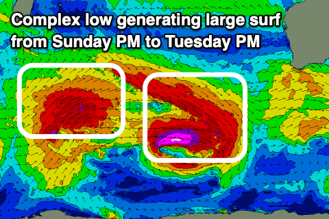
This swell is being generated by a broad, complex low that's formed around the Heard Island region.
A great pre-frontal fetch of severe-gale W/NW winds are being generated with tight, storm-force winds around the core of a low sitting just to the south. Behind this a great fetch of severe-gale W/SW winds are being generated and this will result in back to back pulses of large W/SW groundswell.
The first for later Sunday and Monday morning should peak in the 12ft+ range across the South West, 4ft across Mandurah and 3ft+ in Perth, easing slowly through the day ahead of a secondary slightly smaller W/SW groundswell for Tuesday afternoon.
This looks to pulse back to 10ft+ in the South West, 3-4ft in Mandurah and 3ft across Perth.
Locally winds on Monday will remain out of the northern quadrant, gusty NE, tending N/NE during the day while strengthening, favouring selected spots.
Tuesday should be doable with moderate to fresh NE-N/NE winds, strengthening as a mid-latitude forms to our west and starts moving east.
The low is due to cross us on Wednesday bringing strong N-N/NW tending W/NW winds along with a large, stormy, building W/SW swell thanks to developing gale-force winds on its western flank.
No quality is due from this close-range storm, with easing surf and strong S/SW winds due Thursday, shifting back to the W/NW on Friday ahead of the next front.
This next frontal progression looks significant, generating more large surf into next weekend with what looks to be workable winds in the north. More on this Monday. Have a great weekend!


Comments
Craig any idea when this pattern of NE winds will break and we might get some SE wind patterns?