Large surf continues with lighter winds for the weekend
Western Australia Surf Forecast by Craig Brokensha (issued Wednesday July 19th)
Best Days: Perth and Mandurah tomorrow morning, Saturday, Sunday morning, Monday selected spots
Features of the Forecast (tl;dr)
- Easing swell Thu with strong W/NW winds, moderate E/NE-NE in Perth and Mandurah early
- Strong but easing W-W/SW winds Fri with a large, building mid-period W/SW swell late, easing Sat with variable morning winds (E/NE Perth and Mandurah, E/NE-NE Margs and N/NW arvo)
- Easing surf Sun with moderate N/NE tending fresher N winds (NE Perth and Mandurah)
- Oversized W/SW groundswell possibly showing later Sun, peaking Mon with gusty N/NE-NE tending stronger N winds
- Poor Tue wth strong N/NW tending S/SW winds
Recap
Poor surf across the South West yesterday with large surf continuing to 8ft+ or so, workable to the north and best in Perth with 2-3ft sets, 3ft across Mandurah and more wind affected.
Today we've got terrible, stormy conditions with strong to gale-force onshore winds across all locations, XL in the South West, 4-5ft across Mandurah and 4ft in Perth.

Chunky, onshore Perth today
This week and next (Jul 20 - 28)
Today's strong cold front and XL swell will ease off through tomorrow and we'll see a window of decent conditions across Perth and Mandurah through the morning, moderate from the E/NE-NE creating peaky, lumpy conditions while a strong W/NW breeze looks to persist in the South West.
The South West should ease back from the 12ft range, with 4ft surf in Mandurah, 3-4ft in Perth.
All locations will go back onshore on Friday with a large, building mid-period W/SW swell, generated by the front moving in from the west-southwest over the coming days.
Strong W-W/SW winds are due to shift W/SW through the day and ease while we should see the swell building back to the 12ft range across the South West into the late afternoon, 3-4ft across Mandurah and 3ft+ in Perth.
What we're most interested in though is the weekend, and the forecast lighter winds in Monday's forecast.
This forecast is hold with a variable E/NE-NE breeze due across the South West Saturday morning with E/NE winds to the north giving into N/NW sea breezes that look light (moderate in the South West).
This will be along with a large, easing mid-period swell from the 10ft range in the South West, 3-4ft Mandurah and 3ft across Perth on the sets.
Sunday looks smaller and with moderate NE winds across Perth and Mandurah, N/NE in the South West, freshening a little during the day but likely holding from the N'th.

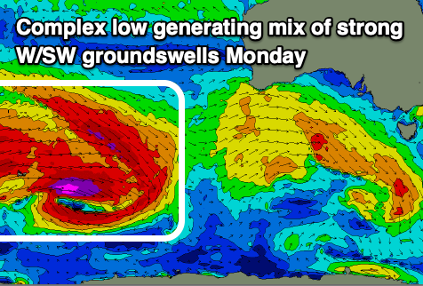
We then look at our large, long-period W/SW groundswell due into Monday next week.
A broad, complex low moving across the Heard Island region tomorrow and Friday will generate a great pre-frontal fetch of gale to severe-gale W/NW winds will be closely followed by similar strength W/SW winds, weakening while pushing towards us.
The low isn't quite ideal with the fetches within being a little unconsolidated but we should still see a significant W/SW groundswell coming in at 12ft+ across the South West, 3-4ft in Mandurah and an inconsistent 3ft across Perth.
Winds look workable early and fresh from the NE-N/NE strengthening through the day while shifting more N'th favouring selected spots.
Tuesday then looks poor as a trough brings a NNW tending S/SW change along with some localised building windswell as a mid-latitude low forms to our west. More stormy onshore surf is expected but we'll look at this closer on Friday.

