Large to extra-large swell pulses with tricky winds
Western Australia Surf Forecast by Craig Brokensha (issued Monday July 17th)
Best Days: Today all locations, keen surfers early tomorrow Perth/Mandurah, Saturday morning all locations, Sunday morning all locations, selected spots Monday morning
Features of the Forecast (tl;dr)
- Large W/SW groundswell peaking this afternoon with variable winds in the South West, fresher N to the north
- Easing swell tomorrow with strong N-N/NW winds in the South West (gusty N/NE early Perth and Mandurah)
- XL W/SW groundswell Wed with strong W'ly winds
- Easing swell Thu with strong W winds, strengthening from the W/NW to the north (outside chance of variable winds early)
- W winds Fri with a building mid-period W/SW swell late, peaking Sat with variable morning winds (E/NE-NE Perth and Mandurah)
- Oversized W/SW groundswell building Sun with fresh NE tending N winds
- Easing swell Mon with N tending NW winds
Recap
Saturday was a sight for sore eyes across the South West with the first offshore morning in a long time greeting surfers. The swell was still in the 6-8ft range and a little raw but there were no complaints. To the north Mandurah and Perth were also nice and clean and to 2-3ft.
Yesterday was a bit smaller and less than ideal as winds shifted to the north and started to increase in Perth and Mandurah, choppy across the South West.
Today a mix of new swells have kicked the sized back again and conditions are best across Perth and Mandurah with early N/NE winds that are now freshening along the latter. The South West was a little wind affected early but is now cleaning up along with sets pushing 8ft.
We should see the W/SW groundswell peaking to 8ft+ this afternoon as winds remain light and favourable across the South West, fresher and less than ideal out of the N'th in Perth and Mandurah.

Clean conditions Saturday morning


Fun metro peaks today and improving conditions with a large swell in the South West
This week and weekend (Jul 18 - 23)
Make the most of the improving surf across the South West this afternoon as winds will become strong from the N-N/NW tomorrow morning along with similar sized surf to this afternoon across all locations.
The South West should still be in the 8ft range but easing with 3ft sets across Mandurah and 2ft+ waves in Perth with a window of gusty N/NE winds early.
Winds will shift W'ly and strengthen on Wednesday as a strong, but weakening low pushes in from the west.
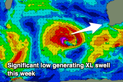
This low is currently generating a fetch of gale to severe-gale W/SW winds and will push closer towards us while weakening and splitting in half.

This will generate an extra-large pulse of W/SW groundswell for Wednesday, mixed in with local windswell, reaching 15ft across the South West, 4ft+ across Mandurah into the afternoon and 4ft across Perth.
The swell will start to ease Thursday as winds ease a little but remain strong from the W in the South West, strengthening W/NW across Perth and Mandurah. There's an outside chance for variable winds early Thursday in northern locations but we'll review this on Wednesday.
Winds look to remain onshore out of the W through Friday as another frontal system clips the state, bringing a fresh pulse of moderate-large mid-period W/SW swell for later Friday but more so Saturday.
Sets to 8ft+ are due in the South West Saturday, 3ft in Mandurah and 2-3ft across Perth with more variable winds. Perth and Mandurah should see a E/NE-NE breezes and it's a window worth keeping an eye on.
Sunday looks decent as well with a temporary low point in swell and morning NE winds that will freshen from the N'th through the day.
During the day and more so afternoon, we're looking at an oversized, long-period W/SW groundswell filling in, generated by a significant frontal progression developing in the southern Indian Ocean later this week.
EC is a little weaker than GFS but we should see a great fetch of at least severe-gale winds producing at least 10-12ft of groundswell for the South West, much larger if GFS gets its way.
We'll have to deal with winds out of the northern quadrant when it peaks either later Sunday or early Monday, so check back here on Wednesday for a clearer idea on the timing, size and local winds.

