A couple of windows of cleaner conditions
Western Australia Surf Forecast by Craig Brokensha (issued Friday July 14th)
Best Days: Today all locations, tomorrow (South West in the morning), Monday all locations, Tuesday morning Perth and Mandurah, Friday Perth and Mandurah
Features of the Forecast (tl;dr)
- Mod-large, easing SW swell tomorrow with E/NE tending N/NE-N and then fresher N-N/NW winds in the South West, E/NE tending N/NE to the north
- Mod-large SW groundswell for Sun, peaking in the PM with strong N/NW tending NW winds, freshening N/NE to the north in the AM
- Large W/SW groundswell building Mon, peaking into the PM
- S tending SE and E winds in the South West, E/NE tending N/NE then N/NW to the north
- Strong N/NW winds Tue with building surf
- Oversized W/SW swells Wed/Thu with strong W/SW winds Wed, fresh Thu
- Easing surf Fri with W winds in the South West, variable Perth and Mandurah
Recap
Poor conditions with a large kick in swell through yesterday, while today we've got improving conditions across all spots as the swell generating front clears to the west.
The South West is still 8-10ft and winds are now to the south, creating workable conditions in protected spots, lumpy and 3-4ft in Mandurah with 3ft peaks in Perth. Winds should remain generally out of the south most of the day now as the swell eases with protected spots fairing best.


Improving conditions this morning
This weekend and next week (Jul 15 - 21)
With conditions on the slow improve today, tomorrow will be cleaner again with a great, moderate E/NE breeze due in the South West early-mid morning, shifting NE-N/NE later morning and then N-N/NW into the afternoon while freshening.
Winds will remain from the N/NE most of the afternoon to the north and size wise we should see easing 2-3ft sets in Mandurah, 2ft across Perth and 6ft to occasionally 8ft in the South West.
Sunday will become poor as an approaching frontal system brings strong N/NW tending NW winds. Perth and Mandurah should see freshening N/NE winds though with the lack of size will make for average surf.
Into Monday we've now got a trough due to move through right when a good, large W/SW groundswell fills in.
The source of the groundswell is a healthy frontal progression that developed south-east of South Africa is moved east across the southern Indian Ocean, with it now still holding strength to our south-west. This closer-range system is due to generate a good kick in size SW groundswell through Sunday afternoon but with those poor winds.
The longer-range swell is due Monday, building to a peak into the afternoon with 8ft+ sets due in the South West, 2-3ft across Mandurah and 2ft+ in Perth.
As touched on above, winds will improve thanks to the trough moving through, with a S tending SE and then E breeze due across the South West, creating good conditions as the swell peaks.
Locations to the north will be a little trickier with a NE tending N/NE breeze due, variable into the afternoon as the swell peaks.

Make the most of this window on Monday as winds look to quickly strengthen again from the N/NW on Tuesday as the next strong storm moves in from the west.
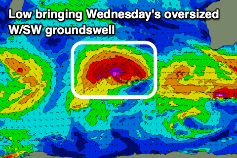
The storm will generate a great fetch of gale to severe-gale W/SW winds while projecting towards us, weakening on approach, followed by a secondary strong system Wednesday evening.
These back to back fronts look to generate oversized pulses of groundswell and mid-period energy out of the W/SW for Wednesday/Thursday but with strong W/SW winds Wednesday, weaker Thursday.
There's a chance for us to fall in between fronts next Friday, bringing light offshore winds for Perth and Mandurah but we'll look at this in more detail Monday.
Longer term we're looking at continued storm activity around the Heard Island region and a large groundswell Monday week, but check back here this Monday for the latest update. Have a great weekend!


Comments
today you can see fresh sandbags up at Pt Moore after large surf erosion:
https://www.transport.wa.gov.au/imarine/geraldton-cam.asp