Easing wind and swell through the weekend
Western Australia Surf Forecast by Craig Brokensha (issued Friday June 23rd)
Best Days: Perth and Mandurah tomorrow morning, all locations Sunday morning, keen surfers in the South West Monday morning, Wednesday in the South West
Features of the Forecast (tl;dr)
- Large, mid-period S/SW swell peaking this evening, easing tomorrow and Sun
- Strong SW winds tomorrow (variable to the north in the AM)
- Fresh SE winds Sun AM, stronger S/SE into the PM
- Smaller Mon with E/SE-SE tending S/SW winds
- Inconsistent, small W/SW groundswell arriving later Tue, peaking Wed with E tending variable winds
Recap
Perth and Mandurah offered clean, fun peaky waves yesterday morning with surf to 2ft+ and light offshore winds, poor in the South West.
Today is bigger across all locations but with poor conditions in the South West, cross-shore and workable to the north with 3ft waves in Mandurah and 2-3ft surf across Perth.
This weekend and next week (Jun 24 - 29)
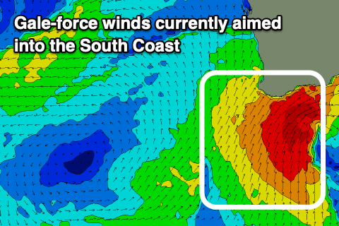
A strong and significant mid-latitude low is sitting off our South Coast, projecting gale-force winds east of Cape Leeuwin, with XXL stormy surf developing, while we should see a peak in large, mid-period S/SW swell across our regions this evening, easing off through the weekend.

A final front projecting towards us tomorrow isn't likely to slow the easing trend too much, with it being weak in nature but we should see improving winds across all locations, best in the South West Sunday.
Looking at tomorrow and the South West should ease back from 10ft to possibly 12ft along with strong strong SW winds. Mandurah should ease back from 3ft to possibly 4ft with 3ft sets in Perth along with variable winds and lumpy conditions.
Sunday should see fresh SE winds in the South West, E/SE-SE across Perth and Mandurah with a weaker, easing swell back from the 6ft+ range in the South West early and 2ft to the north. With these winds in the South West, it'll still be quite raw and average across exposed breaks, better but smaller in protected spots.
Monday will be smaller again and with a touch more favourable E/SE-SE winds in the South West, SE to the north. The South West might still be 3-5ft but slow and south, with Perth and Mandurah becoming tiny and to 1-1.5ft.
High pressure will move in through next week, swinging winds more offshore each morning from Tuesday, along with some inconsistent W/SW groundswell from later Tuesday but more so Wednesday, easing Thursday.
The source was a distant but good frontal progression pushing up under South Africa and then under Madagascar the last couple of days, but the large distance between us will result in a fair loss of consistency and size.
Wednesday should provide infrequent sets to 4ft in the South West with the possible rare 5ft'er on the magnets, tiny to the north.
An E'ly offshore will create clean conditions across all locations in the morning ahead of weak and possibly variable sea breezes.
Longer term we're due to see another progression of frontal activity up and into us from later next weekend but more so the following week. We'll have a closer look at this on Monday. Have a great weekend!

