Plenty of swell with tricky winds
Western Australia Surf Forecast by Craig Brokensha (issued Friday June 9th)
Best Days: Today, early tomorrow Perth and Mandurah, Monday morning Perth and Mandurah
Features of the Forecast (tl;dr)
- Large easing SW groundswell tomorrow with strengthening W/NW winds (lighter and NE early to the north)
- Large mid-period swell building Sun with strong SW winds
- Easing swell Mon with fresh S/SW tending W winds in the South West, E/NE-NE in the AM to the north
- Smaller Tue with strengthening N/NW winds (N/NE early to the north)
- Moderate sized mid-period SW swell building Thu with strong W'ly winds, oversized from the S/SW Fri, peaking later with W/SW winds
- Easing swell next Sat with possible variable morning winds
Recap
Onshore winds were seen across all locations early yesterday morning with the swell dropping further from Wednesday, though conditions improved as winds eased and tended more variable.
This morning we've got a window of light winds and clean conditions along with the arrival of an extra-large SW groundswell.
Perth was clean and to 2ft but now sets are kicking to 2-3ft, with 4ft surf across Mandurah and lumpy 12-15ft waves across Margs. Winds now look better for today with then expected to shift more N/NE before tending N/NW but without any major strength this afternoon. With this target a surf at some stage today.
This weekend and next week (Jun 10 - 16)
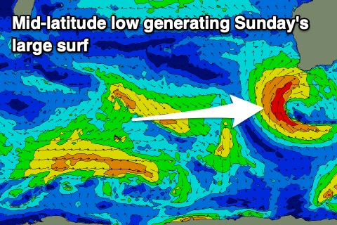
Looking at the weekend ahead, and today's swell will ease through tomorrow and a deepening mid-latitude low to our south-west will bring strengthening W/NW winds to the South West, while Perth and Mandurah should see a window of early, lighter NE winds.
Easing sets from 3ft to possibly 4ft are due across Mandurah early tomorrow, 2-3ft in Perth, with the South West easing back from the 10ft range.

The mid-latitude low will project a slow moving fetch of strong to sub-gale-force W/SW-SW winds towards us tomorrow and Sunday, generating a large, mid-period swell that's expected to peak Sunday afternoon but with strong SW winds.
The South West should build build to the stormy 12ft range, 4-5ft late in the day across Mandurah and 3-4ft in Perth.
The low will push further east on Monday allowing conditions to improve across Perth and Mandurah with light, morning E-E/NE winds, though the Margs region will see S/SW tending W winds and a small trailing front clips the state.
The mid-period swell will ease back from the 10ft range in the South West, 3-4ft across Mandurah and 2-3ft in Perth, smaller Tuesday.
The next approaching frontal system will bring strengthening NW winds on Tuesday (N/NE-NE early Perth and Mandurah), though they'll no decent swell generated by this system.

A stronger and slow moving polar frontal progression should generate a new episode of large mid-period come groundswell later next week.
We're expected to see a slow moving gyre of initially strong to at times gale-force winds in our south-western swell window, followed by a final surge of gale-force S/SW winds up and into us on Thursday/Friday.
This will see moderate sized levels of mid-period SW swell building Thursday, with some much larger S/SW groundswell building Friday, easing Saturday.
Winds at this stage during the building stages look onshore during the building stages, cleaner as it eases but we'll review this on Monday. Have a great weekend1

