Slim pickings this period, best tomorrow
Western Australia Surf Forecast by Craig Brokensha (issued Friday February 3rd)
Best Days: Tomorrow late morning to early afternoon, keen surfers Friday morning
Features of the Forecast (tl;dr)
- Inconsistent, moderate sized S/SW groundswell building tomorrow with strong E/NE winds, tending variable ahead of early-mid afternoon sea breezes
- Easing swell Sun with strengthening S/SE winds
- Smaller Mon and Tue with strong S/SE-SE winds Mon AM and E/SE winds Tue AM
- Building mid-period swell Fri with gusty S/SE tending S/SW winds
Recap
Windy easing surf from 4-5ft+ yesterday morning in the South West, 1-1.5ft across Perth and Mandurah and with no real drop in the wind speeds through the day a they shifted S/SE in the South West.
Today is cleaner but a bit smaller with a reinforcing S/SW groundswell to the 4ft range on the South West magnets, tiny to the north.

Glassy conditions with a wait for these sets this AM
This weekend and next week (Feb 4 - 10)
The surf is expected to ease through the day across the South West with favourable winds until early afternoon before S/SE-S/SW sea breezes kick in.
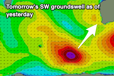
There might be a temporary low point in size at dawn tomorrow but a new S/SW groundswell is expected to arrive through the morning, building to 4-6ft across the South West magnets into the afternoon. Perth and Mandurah aren't expected to see any size from this source at all.

This swell was generated by a strengthening extra-tropical low drifting south-east into the Southern Ocean while generating a great fetch of severe-gale W/NW winds a little off axis from our ideal swell window.
Winds will be strong out of the E/NE tomorrow morning, easing before sea breezes kick in early afternoon.
The swell is due to ease through Sunday and a trough is due to bring poor S/SE winds that will strengthen through the day. Further north winds will be E/NE, shifting W/SW and then S/SW.
Unfortunately the outlook for the rest of the week is poor with the swell due to continue easing through Monday with strong morning S/SE- SE winds, E/SE on Tuesday but with no size.
Later in the week, a mid-latitude low forming right off our south-west looks to generate a new moderate sized SW swell for Friday but with less than ideal winds.
The low will weaken and clip us, bringing S/SE winds on Friday morning when the swell peaks to 4-6ft in the South West, 1-2ft in Mandurah and 1-1.5ft across Perth.
Following this mid-latitude it looks like another mid-latitude low will push up into us on the weekend bringing onshore winds and some new weak swell. More on this Monday, have a great weekend!


Comments
Looks like the north west will be getting a run of useful swell.