Easing surf with a large swell for early next week
Western Australia Surf Forecast by Craig Brokensha (issued Wednesday January 25th)
Best Days: Tomorrow morning South West magnets, Saturday morning in the South West, Monday, Tuesday morning, Wednesday, Thursday and Friday mornings across Margs and Mandurah
Features of the Forecast (tl;dr)
- Smaller Thu with fresh E/SE-SE tending S/SW winds
- Small Fri with strong S/SW-SW winds
- Small mid-period SW swell for Sat, peaking in the PM, easing Sun
- Mod-fresh E/SE winds developing Sat AM ahead of sea breezes, gusty SE-S/SE Sun AM
- Large SW groundswell filling in Mon with fresh SE tending S/SE winds (S/SW to the north)
- Easing surf Tue with gusty E/SE tending SW winds
- Reinforcing surf for Wed PM/Thu with E/SE winds each AM
Recap
A good kick in SW groundswell yesterday but best out of the wind across the South West, 2ft in Mandurah and tiny across Perth.
Today the swell has eased with lighter winds and fun 4ft surf in the South West, 1-1.5ft across Mandurah and 1ft in Perth.
This week and next (Jan 26 - Feb 2)
The surf will continue to ease tomorrow, slowed slightly in the South West by a small reinforcing mid-period swell. This should maintain 3ft to occasionally 4ft sets across the magnets in the morning, tiny and to 1ft in Mandurah and Perth.
Winds should be better and SE-E/SE across the South West in the morning ahead of sea breezes. Friday will be a lay day with a trough bringing S/SW-SW winds to the South West along with no new swell.
The trough inked to Friday's change will be attached to a weak front, with a fetch of strong SW winds being projected up and towards us. This will generate a weak mid-period SW swell for Saturday, peaking into the afternoon to 4-5ft as winds shift E/SE through the morning before strong sea breezes kick in.

Gusty SE-S/SE winds are due into Sunday as the swell eases, though replaced by some stronger, building mid-period SW swell through the late afternoon but more so Monday. This and a larger pulse of SW groundswell for Monday will be generated by the same system.
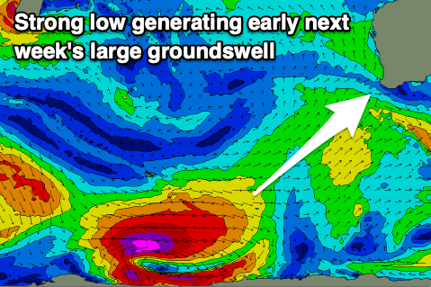
That being a polar low forming around the Heard Island region tomorrow. A great fetch of severe-gale to storm-force W/SW winds should be projected east-northeast, with slightly weaker strong to gale-force W'ly winds at the head of the low.
This pre-frontal fetch should generate a moderate sized+ pulse of mid-period swell just ahead of the groundswell, with both filling in and peaking Monday.
The South West should see 8-10ft sets with Mandurah building to 2-3ft and Perth to 2ft.

How are local winds looking? Good, a fresh SE'ly is due through the morning on Monday ahead of strong S/SE winds in the South West, S/SW to the north, and then E/SE winds Tuesday morning as the swell eases.
The easing trend will be slowed into Wednesday afternoon and more so Thursday thanks to a reinforcing SW swell, generated by trailing frontal activity behind the strong polar low. Surf to 5-6ft should continue across the South West with 2ft waves in Mandurah, 1-2ft in Perth along with morning offshore winds.
Following this the outlook is a bit slower, but more on this Friday.

