Poor weekend, good swell next week aside from the winds
Western Australia Surf Forecast by Craig Brokensha (issued Friday January 20th)
Best Days: Protected spots Tuesday morning and Wednesday morning, exposed magnets in the South West Thursday morning
Features of the Forecast (tl;dr)
- Small mid-period SW swell for later today, easing Sat with fresh E/SE-SE tending strong S/SW-SW winds
- Inconsistent, moderate sized + SW groundswell building Mon PM, peaking Tue, easing Wed
- Strong S/SE tending S/SW winds Mon and Tue
- Easing surf Wed with gusty S/SE-SE tending S/SW winds
- Smaller, fading surf Thu with mod-fresh morning E/SE winds
Recap
Windy but clean and rapidly easing surf yesterday. 3-4ft at dawn but down to 2ft in the afternoon with sea breezes and near flat today. Perth and Mandurah have been clean but tiny, bottoming out today.
This week and next (Jan 21 - 27)
There's a small pulse of background mid-period SW swell due later today, easing tomorrow and this may produce 2-3ft waves on the exposed South West magnets, tiny elsewhere.
Winds look favourable early and E/SE, tending SE through the morning before sea breezes kick in.
Sunday should play out similar wind wise but with no swell.
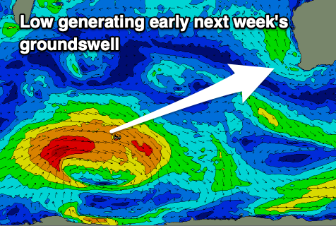
Now, moving into early next week, our fun sized SW groundswell that's due to build Monday and peak Tuesday is on track.

A strong polar low forming to the south of South Africa earlier this week has been generating a fetch of W/SW gales while moving slowly east.
The low is now weakening in the Heard Island region and we'll see the swell spread out and up towards us, generating a moderate sized + SW groundswell, building to 4-5ft by dark on Monday but peaking Tuesday to a good 6ft in the South West, 2ft on the sets in Mandurah and 1.5ft in Perth.
Winds aren't the greatest unfortunately with a trough moving in Sunday evening bringing strong S/SE winds on Monday (E/SE further north), before sea breezes kick in and then strong S/SE tending S/SW winds across all locations on Tuesday.
Winds may tend a little more SE on Wednesday morning but likely remain gusty out of the S/SE as the swell eases, cleaner Thursday with an E/SE offshore. Perth and Mandurah will be tiny and the South West easing from 3ft to possibly 4ft.
Longer term the swell will continue to fade into the end of the week ahead of a small, mid-period SW swell for next Sunday. This may be followed by a secondary, stronger swell but we'll have to review this on Monday as the models diverge. Have a great weekend!

