Poor until later next week
Western Australia Surf Forecast by Craig Brokensha (issued Friday June 25th)
Best Days: Desperate surfers selected spots in the South West tomorrow, Perth and Mandurah Wedneday, Thursday
Features of the Forecast (tl;dr)
- Easing surf with fresh N/NE-NE winds tomorrow
- Building NW windswell and W groundswell Sun with strong N/NE tending NW winds
- Large W swell Mon with strong W/SW tending W/NW winds
- Large, stormy W/SW swell with strong W/SW winds
- Large SW swell Wed with fresh SW winds (light and variable most of the day Perth and Mandurah), cleaner and easing Thu
Recap
Really fun waves yesterday with a new swell and great conditions across most locations all day. Margs saw 4-5ft+ waves into the afternoon but only 1-1.5ft further north. Today the swell has eased a touch in the South West along with a workable, fresh N'ly wind and tiny 1-1.5ft waves further north.

Yesterday looking the goods
This weekend and next week (Jun 26 – Jul 2)
I hope you got stuck in yesterday as we've got a run of poor conditions and building swell into early next week, improving into the end of the week.
Currently a slow moving mid-latitude low is pushing in slowly from the west and as it nears tomorrow it'll swing winds back to the NE-N/NE, fresh in nature but with a further drop in swell from today. If you're desperate try the northerly friendly swell magnets in the South West.
Come Sunday winds will become stronger out of the N/NE, shifting NW into the afternoon and W/NW late as the mid-latitude low pushes in.
 A poor quality windswell out of the N/NW will be seen across all locations ahead of the groundswell from the low into the afternoon, peaking Monday.
Size wise, there's no change since Wednesday with sets to 6-8ft due in the South West, 3ft further north but with fresh to strong W/SW tending strong W/NW winds in the South West, a touch weaker in Perth and Mandurah.
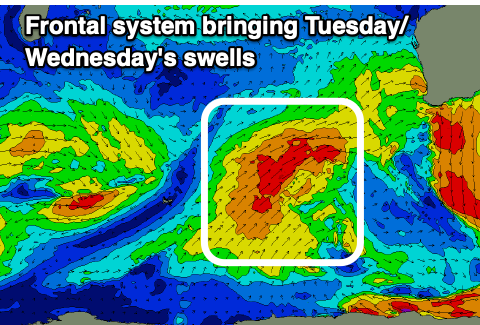
The secondary polar front that's due to push up and into us Tuesday is on track with it projecting W/SW gales towards us, weakening a touch while moving across us.
The front itself will bring a large, stormy increase in mid-period swell Tuesday to the 10ft range across the South West, 3-4ft further north, with the groundswell filling in Wednesday and coming in around a similar size.
Strong W/SW winds will hold Tuesday, improving Wednesday and easing, shifting SW. Perth and Mandurah may see variable winds all day and lumpy, improving surf.
Thursday looks to offer the first opportunity for a wave with quality in the South West as winds swing back offshore in some form with easing sets from the 8ft range on the swell magnets, 2-3ft further north.
Following all this activity a strong high is due to move in swinging winds more north along with no new significant swell. Therefore try and plan around the cleaner days through next week as the surf eases. Have a great weekend!

