Mixed end to the week, slow weekend and more action next week
Western Australia Surf Forecast by Craig Brokensha (issued Wednesday June 9th)
Best Days: Keen surfers Friday, beaches Saturday morning, keen surfers Tuesday and Wednesday mornings
Features of the Forecast (tl;dr)
- Stormy, easing W/NW swell tomorrow with strong W/NW tending W/SW winds
- Cleaner but small Fri AM, fading surf on the weekend with light, morning offshore winds
- New, mid-period W/SW swell building Sun PM, peaking Mon AM with strong S/SW winds (S/SE Perth and Mandurah)
- Secondary pulse of swell for Mon PM, easing slowly Tue with fresh S/SE winds (SE Perth and Mandurah)
- Reinforcing, large SW swell next Thu with light winds
Recap
Great surf yesterday across the South West with glassy, 6ft+ waves on the swell magnets in the morning, becoming windier but remaining clean into the afternoon while slowly easing. Perth and Mandurah were 2ft and clean most of the day, while this morning the swell has eased and winds are strengthening from the NE across the state.
This is due to a deepening mid-latitude low to our west, with winds due to continue to strengthen this afternoon while tending N/NE. This will generate a building N'ly windswell but with poor conditions.
This week and next (Jun 10 - 18)
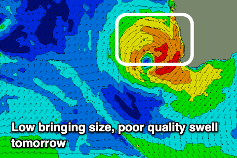
 The mid-latitude low currently strengthening to our west will drift slowly south-east through this evening and across us tomorrow morning, with a bit more strength and swell potential from its northern and western flank.
A fetch of strong to near gale-force W/NW-W/SW winds should generate a poor quality 6-8ft of W/NW swell for the South West tomorrow morning, easing through the day with 3ft waves across Perth and Mandurah.
Conditions will be poor though with a strong W/NW tending W/SW breeze across all locations, cleaner and more variable into Friday morning out of the E/NE.
Size wise Friday, the swell looks smaller and the models are over-forecasting the expected size, combining a new, long-range and small groundswell with the existing, mid-period energy.
Instead it looks like we're only due to see 3-4ft surf in the South West and fading 1-2ft sets max to the north.
Saturday looks smaller and with light SE winds across the South West, E/SE further north, clean again Sunday but with a low point in swell.
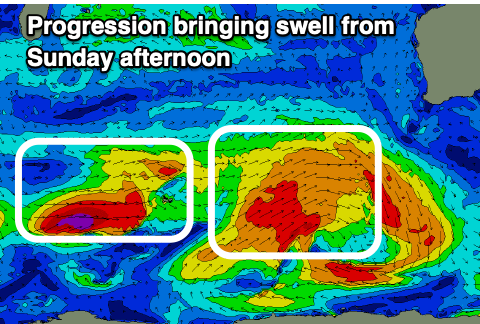
Moving onto our new W/SW swell due into Monday and Tuesday, and the frontal progression linked to this now looks a touch weaker and with seperate cold fronts projecting up and towards us, generating differing, moderate-large pulses of surf.
An initial pre-frontal fetch of strong to gale-force W/NW tending W'ly winds should generate an afternoon kick in size Sunday, to 5-6ft across the South West by dark, 1-1.5ft further north, while a fetch of W/SW gales right on the backside of the progression should generate a secondary, better pulse of swell for Monday.
The South West should offer 6-8ft+ surf, 2-3ft in Mandurah and 2ft+ across Perth.
 One final mix of closer-range SW swell and new mid-period W/SW swell is due Monday afternoon and Tuesday, generated by secondary front piggybacking on top of the initial progression, then projecting up and into us Monday afternoon.
This looks to kick the South West to a larger 8ft+ into the afternoon, easing back from a similar size Tuesday morning. Perth and Mandurah should ease back from 3ft on the sets.
Winds on Monday with the front look poor and strong from the S/SW (S/SE early Perth and Mandurah), tending S'ly on dark, with strong S/SE winds on Tuesday (SE in Perth and Mandurah).
Wednesday morning may see cleaner conditions as the swell eases back in size.
Longer term, a large, reinforcing groundswell is due Thursday with favourable winds, but we'll have a closer look at this and any change to the winds Tuesday next week on Friday.


Comments
Flooding in Exmouth it looks serious I hope they don't get washed away.
Mental, slow moving trough!
Saw some pictures on ABC, that's some serious bit of water for Exy