Fun surf continues
Western Australia Surf Forecast by Craig Brokensha (issued Wednesday March 31st)
Best Days: Thursday morning, Saturday afternoon in the South West, Sunday morning
Features of the Forecast (tl;dr)
- Easing mid-period W/SW swell tomorrow with favourable winds, smaller Friday and deteriorating, strengthening S/SE winds
- Mid-period S/SW swell building Sat, easing Sun (peaking Sun AM in Perth and Mandurah) with generally favourable winds (not so much in the South West Saturday with strong SE breezes, tending variable)
- Strong, new S/SW groundswell on the cards for next weekend
Recap
The first pulse of W/SW swell filled in nicely yesterday with light winds and clean 4-6ft sets across the South West in the morning (holding today) 2ft across Mandurah and bigger into the afternoon with 2-3ft sets this morning but with some slight bump. Perth was a clean 1-2ft yesterday, similar again today with light winds.
This week and next (Apr 1 - 9)
The surf should hold a similar size into tomorrow morning as the final pulse of mid-period W/SW swell fills in overnight, keeping 4-6ft surf hitting the South West, 2-3ft in Mandurah and 1-2ft across Perth, easing through the day and smaller Friday.
Conditions should be nice and clean across all spots with an E'ly offshore in the South West, tending E/NE and then with weak sea breezes, with S/SE-SE morning winds in Perth and Mandurah.
A trough will move in Friday bringing strengthening S/SE winds, more variable in Perth with afternoon sea breezes.
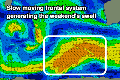
 Our new, mid-period S/SW swell for the weekend is on track with a broad, though not overly strong polar front due to project up towards us this evening, generating strong W/SW-SW winds. The front will be slow moving, helping to generate some healthy size, with building surf Saturday to 4-5ft+ into the afternoon, easing from a similar size Sunday morning.
Perth and Mandurah probably won't see any size until Sunday with sets to 2ft across Mandurah, 1-1.5ft in Perth with the possible odd 2ft set.
Conditions on Saturday will be windy across the South West, with a strong SE offshore, lighter into the afternoon and E/SE-E/NE tending variable winds further north.
E-E/NE offshores are due Sunday ahead of afternoon sea breeze, so get in through the morning. Come Monday the swell will be on the ease and a trough will bring a W'ly change that'll only be temporary, with offshore winds due back into Tuesday.
Longer term, strengthening but not overly consolidated frontal activity should produce some new swell late week, with a larger S/SW groundswell on the cards for next Saturday. More on this in Friday's update though.

