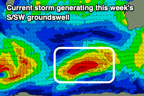
Windy week, with a couple of swells
Western Australia Surf Forecast by Craig Brokensha (issued Friday January 8th)
Best Days: Protected spots for the keen tomorrow AM, Thursday, Fri AM in the South West for the desperate
Features of the Forecast (tl;dr)
- Mid-period S/SW swell for tomorrow with gusty S/SE morning winds
- Moderate-large S/SW groundswell for Thursday with strong morning SE winds
Recap
Fun waves to start the weekend with a new kick in inconsistent groundswell with 4-6ft waves across the South West, 2ft in Mandurah and 1-2ft across Perth, with all regions easing yesterday with poor conditions.
Today the surf has cleaned up a little with tiny waves continuing across Perth and Mandurah, better and to 3-4ft in the South West.
This week and weekend (Jan 12 - 17)
We've got a new, mid-period S/SW swell due tomorrow across the South West and Mandurah, lifting wave heights slightly on today. The weakening front linked to this swell is now pushing east through the Bight, with the swell due to kick late today but peak tomorrow morning to 4-5ft+ in the South West, 1-2ft across Mandurah and 1-1.5ft in Perth.
Winds won't be ideal with a gusty S/SE breeze across the South West, lighter and more SE to the north, shifting strong S/SW across all locations into the afternoon.
 The swell is due to back off into Wednesday morning with slightly better though still windy, morning SE winds, giving into strong S-S/SW winds through the afternoon as our stronger S/SW groundswell starts to show.
Similar to Friday's predictions, this swell is on track, with it being generated by a healthy polar low that's fired up around the Heard Island region. A fetch of W/SW gales are being projected through our southern swell window, with the low due to weaken while projecting north-east towards us, producing some additional mid-period swell.
Size wise, a peak is expected Thursday morning with 6ft+ sets across the South West, 2ft+ in Mandurah and 2ft on the sets across Perth with strong SE winds in the South West (possibly E/SE at times), and more E/SE in Perth and Mandurah, stronger S/SE into the afternoon.
The wind may back off a touch Friday in strength with the swell due to ease fairly quickly, back from 3ft+ in the South West, tiny to the north.
Moving into the weekend there’s no new swell on the cards and winds will swing more easterly in direction as the heat builds owing to a deepening heat trough across the state.
We may see a small, inconsistent, mid-period SW swell early next week from unfavourably aligned and patchy W/NW fetches spinning around a low west of the Heard Island region. Other than that the outlook remains average, so make the most of the coming swells.

