Easing surf with a new swell for the weekend and potential next week
Western Australia Surf Forecast by Craig Brokensha (issued Wednesday December 30th)
Best Days: Tomorrow morning, Saturday later morning ahead of sea breezes, Sunday morning, Tuesday morning, Wednesday morning
Features of the Forecast (tl;dr)
- Easing W/SW groundswell with great winds tomorrow AM ahead of sea breezes
- Fun, mid-period SW swell for the weekend, clean and easing Sun AM
- New S/SW groundswell likely Wed with morning offshores
Recap
Windy, small surf to start off yesterday, tiny to the north but into the afternoon the fore-runners of our large, long-period and inconsistent W/SW groundswell filled in, pulsing strongly late in the South West. Sets to 8ft were seen with strong cross-shore winds, with today coming in a bit slower with slow 6ft+ sets on the exposed reefs.
Perth saw the swell today with clean, infrequent 2ft sets, 2-3ft across Mandurah.

Solid sets late yesterday
This week and weekend (Dec 31 – Jan 3)
It appears our inconsistent W/SW groundswell peaked late yesterday with the initial surge in size through the evening ahead of a more steady, inconsistent 6ft to occasionally 8ft wave through today in the South West.
We'll see the size easing through tomorrow with favourable conditions across all locations under a fresh and gusty E-E/SE wind, lighter E/NE across Perth, with sea breezes kicking in midday/early afternoon.
The South West should ease back from the inconsistent 5-6ft range, 2ft across Mandurah and 2ft on the sets in Perth.
Friday will be smaller and with less favourable winds, fresh SE, stronger from the S'th into the afternoon.
Looking at the weekend and our fun, mid-period SW swell for Saturday is on track, with a broad polar frontal system forming around the Heard Island region yesterday evening. We're seeing a broad fetch of strong to sub-gale-force W/SW winds generated through our south-western swell window, with a moderate sized SW swell due to fill in Saturday, building to a peak through the afternoon.
There's no change to the expected size with the South West due to reach 4-6ft on the swell magnets, 2ft in Mandurah and 1-2ft in Perth. The swell is then due to ease Sunday from 3-5ft, 1-2ft and 1-1.5ft respectively.
It'll be a little windy Saturday with strong morning SE winds, S'ly and windier into the afternoon, then fresh to strong E/SE Sunday, easing ahead of sea breezes.
 Following the current, broad polar frontal progression, a weaker, smaller progression looks to generate a small, reinforcing SW swell for later Monday but more so Tuesday, though only likely peaking around 4ft+ in the South West, tiny further north. Conditions will be favourable though with a fresh morning E/SE offshore Tuesday morning.
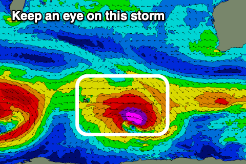
Longer term, we may see a stronger polar low forming south-west of us on the weekend, producing a larger S/SW groundswell for mid-week, and with offshore winds. We'll have to keep a close eye on this and provide an update on Friday and Monday.


Comments
Wind effected in the North West today. But what a beautiful swell, (like a cyclone swell.) So feasting on mushburgers was quite fulfilling. I was wearing my Batman outfit too. But the cape boardriders still won't accept me into their exclusive club.