Large, strong swell next week
Western Australia Surf Forecast by Craig Brokensha (issued December 25th)
Best Days: Keen surfers South West magnets Monday morning, Wednesday, Thursday morning
Features of the Forecast (tl;dr)
- Poor, windy weekend
- Small new S/SW swell for Mon with cleaner conditions
- Strong, large W/SW groundswell building Wed with good winds, easing Thu
Recap
The swell dropped out yesterday with less than ideal winds, increasing a touch today though wind affected across most locations.
This weekend and next week (Dec 26 – Jan 1)
There's nothing to really get excited about over the weekend with the small lift on mid-period S/SW swell today due to ease back tomorrow, becoming tiny Sunday with strong morning S/SE winds tomorrow morning, SE and strong Sunday morning.
A weak polar front pushing up towards us, just clipping the south west tomorrow afternoon will produce a small pulse of new mid-period S/SW swell for Sunday afternoon and Monday morning, but again size wise there's nothing to it. It'll be very south in nature and only likely come in at 3ft across the South West south swell magnets later Sunday and Monday morning. Perth and Mandurah will remain tiny.
Conditions on Monday morning look favourable though with a moderate to fresh morning E/SE wind, giving into afternoon sea breezes.
More important is the large, long-period, though inconsistent W/SW groundswell due into the middle to end of the week, with the low linked to this forming south of South Africa Wednesday.
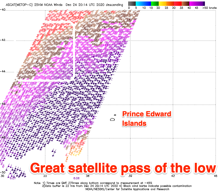
A great fetch of storm-force W/SW winds have been directed at us as shown in the satellite pass below, and we'll continue to see severe-gale to storm-force winds aimed towards us through today as the low slowly weakens and dips south-east.

The longevity of the low and storm-force fetch should produce a strong, large though inconsistent W/SW groundswell with the fore-runners due to arrive Tuesday ahead of the bulk of the swell Wednesday.
Later Tuesday good sets should be seen with a peak expected Wednesday afternoon to an easy 6-8ft in the South West, with the odd 10ft more than likely, 2-3ft in Mandurah and 2ft to possibly 3ft across Perth. Morning winds as it builds will be favourable and fresh SE tending E/SE, possibly holding for most of the day to the south as a heat trough deepens along the coast.
Thursday looks great as the swell starts to ease with fresh E/NE tending N/NW winds as the trough pushes south-east. Margs looks to drop from 6ft to possibly 8ft, 2ft+ in Mandurah and 2ft in Perth.
Longer term there's nothing too significant on the cards, so make the most of next week's swell. Merry Christmas!


Comments
Slightly confused for Tuesday & Wednesday did you mean ...
“ Morning winds [Wednesday] as it builds will be favourable and fresh SE tending E/SE, possibly holding for most of the day to the south as a heat trough deepens along the coast.”
Winds for Wednesday on other sites are calling very fresh SE 20-25 knots all day, whereas much lighter Tuesday in the middle of the day? Do you agree?
Yeah Tuesday is now looking better wind wise. Will have the update later but the South West Wednesday looks to see fresh SE tending stronger S/SE winds, E/SE all day in Mandurah and E/SE tending W/NW in Perth. Thursday morning still looks good before winds shift onshore.
Apologies I read that last comment incorrectly :)