Mostly onshore with a large swell in the mix
Western Australia Surf Forecast by Craig Brokensha (issued Monday 9th November)
Best Days: Wednesday morning keen surfers only, Friday afternoon for the keen, possibly Monday morning
Recap
Clean, small waves to kick off the weekend in the South West (tiny to the north) ahead of a new inconsistent groundswell building into the afternoon as winds shifted onshore. Yesterday was onshore and lumpy/bumpy with Saturday afternoon's swell hanging in across Mandurah and the South West.
Today we've got stronger onshore winds and small surf with an afternoon increase in windswell now developing.
This week and weekend (Nov 10 - 15)
Currently a surface trough is deepening into a low directly south-southwest of us and this is bringing strengthening W'ly winds on its northern flank, followed by gale-force S/SW winds this evening aimed into the Margaret River region, with the system moving slowly east tomorrow.
 We'll see strong to possibly gale-force SW winds across the South West tomorrow, strong to the north along with a poor quality localised windswell to 3ft across Perth and Mandurah, 6-8ft in the South West.
Winds should really back off overnight Tuesday and swing offshore out of the E/NE across Perth and Mandurah Wednesday morning, with light S/SE winds in the South West but the swell will be easing, weak and not great.
A drop in localised swell from 4ft is due in the South West, 1-2ft possibly across Perth and Mandurah.
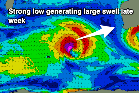
Winds are still expected to swing back onshore and strengthen from the N/NW-NW on Thursday as a cold front spawning off a strong low forming north-east of the Heard Island region moves in.
This low will generate a large W/SW groundswell with a great fetch of gale to severe-gale W/SW winds produced through our western swell window. The swell should arrive on Friday and peak into the afternoon with the South West pulsing to 8-10ft+, 2-3ft across Mandurah and Perth.
 The timing of the front looks to be Friday morning, with SW winds moving in behind it, creating bumpy conditions and swinging W/SW into the afternoon.
Unfortunately a secondary broad mid-latitude front moving in on the back of the low will bring a reinforcing W/SW swell but also onshore winds for the weekend.
Strengthening W/NW tending W breezes are on the cards for Saturday, swinging W/SW-SW on Sunday as the reinforcing swell starts to build. Winds could possibly become variable Monday morning as the reinforcing swell peaks.
We're gonna have to review this but the reinforcing swell should keep the South West around 6-8ft and 2ft+ around Perth and Mandurah.
Longer term it looks like we might see further mid-latitude storms pushing into us, but we'll have a closer look at this Wednesday.

