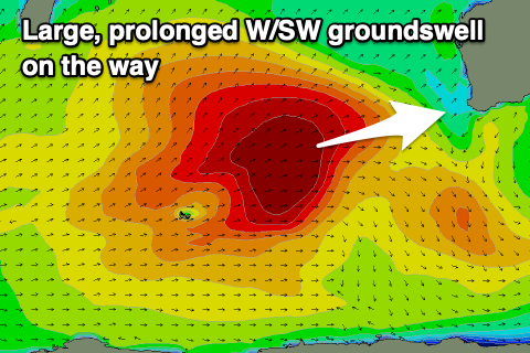
Building, large surf on the way
Western Australia Surf Forecast by Craig Brokensha (issued Monday 26th October)
Best Days: Keen surfers Mandurah and Perth mid-late morning tomorrow, protected spots Wednesday, Thursday morning, Friday morning
Recap
Very small, though clean waves across the South West Saturday and Sunday, tiny to the north.
Today the surf remains minimal with less than ideal winds.
This week and weekend (Oct 27 – Nov 1)
After a run of small surf, we've got a much more active week of waves on the way, initially onshore as it builds but cleaning up through the back half.
During the weekend, a broad, elongated and multi-staged frontal progression projected slowly towards us from the Heard Island region.
 Various fetches of gale to severe-gales have been generated, with the progression still generating an elongated though patchy fetch of strong to gale-force W/SW winds drawn out to the west-southwest of us.
We should see a large, prolonged W/SW groundswell event building through tomorrow and peaking Wednesday.
Coming in a little cold off annual leave it's hard to get the exact scope on the expected size but it looks like the South West should build to 10-12ft later tomorrow, 3ft+ across Mandurah and 2-3ft in Perth, peaking Wednesday to 12-15ft, 3-4ft and 3ft respectively.
The swell is likely to ease through Wednesday afternoon, down further Thursday from the 10ft range in the South West, 3ft across Mandurah and 2-3ft in Perth.
Locally, winds tomorrow will be poor as one of the fronts linked to the progression moves in, bringing moderate W/NW winds in the South West, strengthening into the afternoon. Perth and Mandurah should see NE breezes through the morning, shifting onshore late morning but the swell will be on the smaller side.
We'll see conditions start to improve Wednesday as the front pushes off to the east, swinging winds from the SW to S/SW across the South West, stronger S/SE later in the day, so hunt those protected spots.
Further north Perth and Mandurah should see morning S/SE winds, though strong SW sea breezes.
Thursday is the pick for the cleanest conditions as the swell eases with a fresh E'ly offshore, tending variable through the middle of the day ahead of sea breezes.
Friday looks clean again but the swell will be smaller and on the way out with a moderate to fresh E'ly, giving into afternoon sea breezes. The South West should offer easing 4-6ft sets, smaller to the north.
Our next swell is due to arrive from a deepening mid-latitude low west-southwest of us on the weekend, followed by a broader Southern Ocean frontal progression.
The mid-latitude low is still up for grabs regarding its position and where it'll be aimed. GFS has it into us, but EC has it pushing further north and into the north-west of the state along with better winds.
We'll have to review this on Wednesday along with the groundswell to follow mid-week.

