Large back to back swells
Western Australia Surf Forecast by Craig Brokensha (issued Wednesday 7th October)
Best Days: Most coasts tomorrow morning (a little dicey for the South West), similar Friday morning, Saturday morning, Sunday morning, protected spots Monday and Tuesday
Recap
A drop in size yesterday but still clean, fun and worth a surf across most regions in the morning, wind affected into the afternoon.
This morning the swell has bottomed out and we've got clean conditions for the early across all locations but these are now strengthening from the N.
This week and weekend (Oct 8 - 11)
Today's strengthening winds are associated with an approaching cold front which will clip the state this evening leaving lingering onshore W/SW winds across the South West tomorrow morning that may tend variable as it progresses. To the north much cleaner conditions should be seen with a light morning SE'ly, with all coasts giving into sea breezes.
A large, new W/SW groundswell associated with the front will also fill in, with no change to Monday's expected size. The South West should see easy 8ft sets on the swell magnets, if not for the sneaky bigger one, 3ft in Mandurah and 2-3ft across Perth.
 A drop in size is due Friday and winds look variable tending light offshore across Perth and Mandurah, with the South West possibly also seeing variable morning winds, otherwise a light W/NW breeze will be blowing.
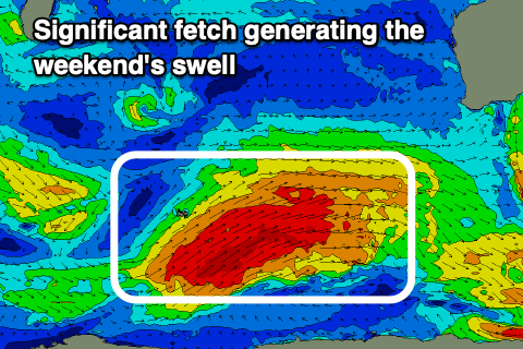
Into the weekend we'll see a larger, long-period SW groundswell fill in across the state, generated by a strong polar front that's currently around the Heard Island region.
A fetch of gale to severe-gale W/SW winds are being generated, moving in on top of the active sea state before it, with it projecting north-east towards us slowly through today and tomorrow, weakening int the evening.
Size wise we should see the swell build strongly to 10-12ft into the afternoon (possibly the odd bigger clean-up), easing from a similar size Sunday morning. Mandurah should build to 3-4ft with 3ft sets across Perth.
The bonus for the weekend is that winds will swing offshore from the E/SE across the South West, with S/SE winds to the north on Saturday ahead of afternoon sea breezes, then more SE on Sunday morning as the swell eases.
 Into Monday, a large reinforcing SW groundswell is on the cards, generated by a strong low firing up on the back of the progression generating the weekend's swell.
A fetch of severe-gale to storm-force W/SW winds are forecast, but over a smaller, tighter area. The size of this swell looks to be 10-12ft+ across the South West, 4ft in Mandurah and 3ft across Perth with morning S/SE winds, similar Tuesday as the swell eases. We'll review this on Friday though.

