Poor, windy, stormy weekend
Western Australia Surf Forecast by Craig Brokensha (issued Friday 18th September)
Best Days: Perth and Mandurah, Monday and Tuesday mornings, Wednesday, Thursday
Recap
Great conditions but a drop in swell on the coast yesterday from 3-5ft in the South West, 1-2ft in Mandurah and 1-1.5ft across Perth. Today the swell is smaller again, bottoming out and only surfable on the South West magnets.
This weekend and week (Sep 19 - 25)
The weekend isn't looking too flash at all as we see a deepening trough come mid-latitude low moving in from the south-west.
The strength of this low has been upgraded since Wednesday and we're now due to see a significant fetch of gale to severe-gale S/SW winds projected up and into the South West corner of the state, kicking up an oversized, stormy S/SW-SW swell.
 Tomorrow as the deepening system moves in, strong W/SW winds will create poor conditions and building levels of low quality swell, building to 6-8ft in the South West, 2-3ft in Perth and Mandurah.
Sunday looks to then see gale-force SW winds across the South West and building stormy 10-12ft+ waves, 4ft across Mandurah and 3-4ft in Perth with strong SW winds.
The low will start weakening and pushing east on Monday but winds will remain strong and out of the SW across the South West as the swell starts to ease.
Perth and Mandurah should see early S/SE winds and cleaner conditions with easing sets from 2-3ft and 3-4ft respectively. Margs looks to still be 8ft or so.
Unfortunately Tuesday will see lingering onshore W/SW winds as a weak front clips the South West along with smaller surf, NE to the north but also on the small side.
Our large, new W/SW groundswell for Wednesday is on track, as are the offshore winds.
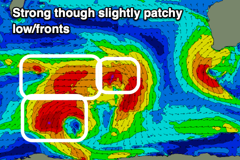
This swell will be generated over the weekend by a broad and strong low that'll form south-east of Madagascar and north-west of the Heard Island region, producing a great fetch of W/SW gales, with embedded severe-gales in the mix.
 Since Wednesday the structure has gone a little off the boil, and I've pegged back the expected size to the 6-8ft range across the South West, 2ft to maybe 3ft in Mandurah and 2ft across Perth.
A high moving in from the west should swing winds E/SE across all locations Wednesday as the new swell fills in, peaking through the afternoon.
We'll see a weak low squeezing the northern flank of the low Thursday, bringing stronger E'ly winds as the W/SW groundswell starts to ease.
Longer term there's nothing too major on the cards so make the most of the window of swell and offshores next week.


Comments
There's something about these colours that instantly says "West Oz".

West is best ; )