Windows opening for select spots
Western Australia Surf Forecast by Craig Brokensha (issued Wednesday 2nd September)
Best Days: Perth and Mandurah Friday and Saturday mornings, Perth and Mandurah Tuesday and Wednesday mornings
Recap
Poor conditions with large stormy waves across all locations yesterday, continuing today.
This week and weekend (Sep 3 - 6)
We'll see onshore winds persist across all locations tomorrow as a strong low that developed east of Heard Island is pushing up and towards us last night , bringing an additional large and stormy W/SW-SW swell today followed by the groundswell tomorrow afternoon, easing Friday.
Strong W-W/NW winds will leave no quality options but come Friday as the swell eases, lighter and more variable winds are due across Perth and Mandurah early, tending W/NW-NW through the day.
 Margs will unfortunately remain onshore all day and size wise, easing sets from 3ft are due in Mandurah, 2-3ft in Perth with easing 6ft to possibly 8ft sets in the South West.
We've got a reinforcing SW groundswell for later Friday, easing Saturday from a small, tight low developing west-southwest of us tomorrow. A fetch of W/SW gales should keep the South West around 6ft+ Saturday morning, 2-3ft in Mandurah and 2ft across Perth. Early N/NE-NE winds will favour Perth and Mandurah, shifting NW into the afternoon, with stronger N/NW tending NW winds across the South West.
The strengthening winds will be ahead of a broad and slow moving storm pushing in slowly from the west, under the influence of a strong node of the Long Wave Trough.
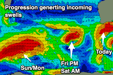
Currently a broad and elongated fetch of W/SW gale to severe-gales are being generated west of Heard Island and this will weaken while morphing into the slow moving system later this week and weekend.
We'll see an even larger area of weaker strong to gale-force W/SW winds moving slowly towards us and then into us Sunday/Monday.
Locally building mid-period and windswell energy is expected along with the more distant groundswell energy from the fetch today, though with strong to gale-force NW tending W/NW winds Sunday, strong Monday out of the W/SW though easing.
 Size wise it looks like the South West will reach Sunday should build to 12ft+ across the South West later and peak Monday to 12-15ft, building to 4ft across Mandurah and 3-4ft Perth, peaking Monday to 4-5ft+ and 4ft respectively.
The swells should ease into Tuesday, further Wednesday and with a window of early NE winds across Perth and Mandurah Tuesday, possibly SE Wednesday but the South West will remain onshore Tuesday, cleaner Wednesday with more variable N'ly winds.
Following early week's activities a much more significant polar low looks to generate an XL, long-period SW groundswell for later week though winds are still suspect. More on this Friday.

