Fun weekend, XXL and onshore through next week
Western Australia Forecast by Craig Brokensha (issued Friday 28th August)
Best Days: Now, Saturday morning Perth and Mandurah, protected spots in the South West, Sunday
Recap
Conditions were clean and good yesterday with a building W/SW groundswell from 4-6ft across the South West, 2-3ft in Mandurah and 1-2ft across Perth, kicking to a large 8ft+, 3ft and 2ft respectively with workable afternoon winds.
Today conditions were clean again across all locations with a variable breeze, though an onshore and strengthening change isn’t far off. The swell is still large across the South West and to 8ft+ on the sets, 3ft in Mandurah and 2-3ft though inconsistent in Perth.

This weekend and next week (Aug 29 - Sep 4)
Today’s onshore change is associated with the tail of the frontal progression linked to yesterday’s and today’s swell wagging a little and it’ll bring strong S/SW winds to the South West, S/SE-SE further north.
 A reinforcing mid-period SW swell should be in the mix along with the easing SW groundswell energy from today with surf to 8ft in the South West, 3ft on the sets across Mandurah and 2ft+ in Perth.
Sunday looks the pick of the weekend with offshore E/NE winds across all locations, swinging more N/NE through the day and holding into the afternoon. The size will be on the ease though with fun, easing 6ft+ sets across the South West, 2ft to possibly 3ft in Mandurah and 2ft across Perth.
Monday looks poor with a low point in swell and a weakening and approaching mid-latitude low will bring strengthening W/NW winds. There’s a window of more variable winds to the north though the swell will be small to tiny.
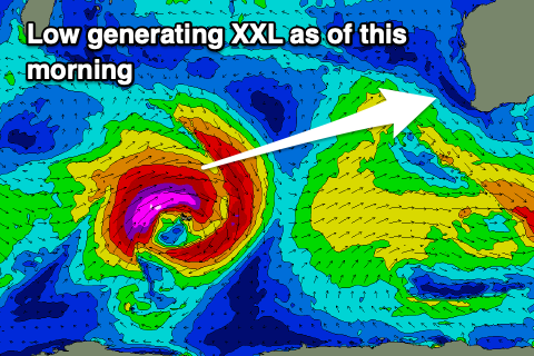
This low is actually currently a severe storm positioned just north-west of the Heard Island region, with it generating a great fetch of severe-gale to storm-force W/SW winds. This low formed south-east of South Africa and will continue to project gales towards us on the weekend while slowly weakening.
We’ll see an XXL long-period swell generated by the low, arriving Monday and kicking very rapidly to 15-18ft+ across the South West, 4ft in Mandurah by late and 3ft in Perth. Tuesday looks a similar size but unfortunately those winds will be strong W/NW Monday afternoon and strong W tending SW on Tuesday.
 This will be as the low moves into us, kicking up a localised stormy swell as well.
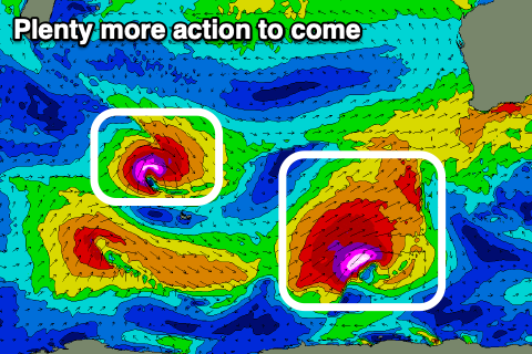
Following the low additional polar and mid-latitude systems are forecast to project up and into us, generating large to extra-large surf through Wednesday with a new XL long-period SW groundswell for Thursday.
Winds look to remain an issue though and onshore through the whole period. Longer term there’s no let up to the incoming fronts and large swell activity owing to a strong node of the Long Wave Trough moving in from the west. More on this Monday though. Have a great weekend!


Comments
The last couple of days felt like winter was coming to a end defenitly not complaining about the incoming forecast
Heating up in the north. Mulla mulla,s in full bloom. Love the XXL swells brings MY hollow left to life.
Is anyone having issues getting the Mandurah swell buoy? Is it off line? Cape Naturaliste and Rotto no problems but Mandurah nothing for a few days? : (
Splat!