Slim window for the weekend, much better next week
Western Australia Forecast by Craig Brokensha (issued Friday 21st August)
Best Days: Margs and Mandurah dawn tomorrow, Monday morning, Tuesday and Wednesday mornings in the South West, Thursday morning in the South West, Friday
Recap
Clean, fun waves across Perth and Mandurah yesterday to 1-2ft and 2ft+ respectively, average in the South West but improving as onshore winds eased with 4-6ft of surf.
Today conditions have improved in the South West with a drop in swell back to 3-5ft, clean and fun to 2ft in Mandurah and holding 1-2ft across Perth.
This weekend and next week (Aug 22 - 28)
There's a small window of clean conditions across all regions tomorrow morning with a dawn NE'ly and small, inconsistent groundswell to 4-5ft across the South West. Further north looks tiny and to 1-1.5ft or so.
Winds will quickly shift to the N and then N/NW, W/NW into the afternoon so aim for the dawn surf.
Sunday still looks poor with a shift in winds to the W/SW, strong early but easing quickly and shifting SW. This will be with the better pulse of W/SW groundswell discussed all week, coming in around 6ft+ across the South West, 2ft+ in Mandurah and 2ft across Perth.
Monday looks the pick as winds shift back to the E/SE tending E/NE and then variable into the afternoon. Margs should be clean and easing from 4-5ft, 2ft on the sets across Mandurah and 1ft to possibly 2ft in Perth.
The swell looks smaller into Tuesday and Wednesday with morning offshore winds, (variable Tuesday afternoon) so aim for the South West for the best waves, but from Thursday through the weekend we should see some better pulses of moderate to large sized W/SW tending SW groundswell.
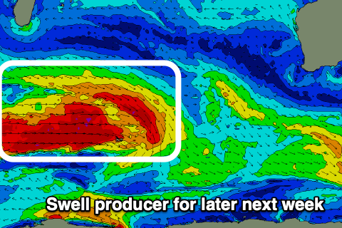
 The source of these swells will be a strong conveyer belt of frontal systems forming south-east of South Africa and pushing east through our western and then south-western swell windows.
Fetches of gale to severe-gale W'ly winds are expected, weakening once nearing closed to us, though we may see a trailing front strengthening directly south-west of us later next week.
In either case an inconsistent and long-period W/SW groundswell from the initial stages is due to build later Thursday and peak Friday, with a reinforcing SW swell for Saturday.
Size wise we're probably looking at a peak around 8ft+ across the South West, 2-3ft in Mandurah and 2ft+ across Perth with favourable winds. More on this Monday though. Have a great weekend!

