Large swells on the way as winds slowly improve
Western Australia Surf Forecast by Craig Brokensha (issued Wednesday 29th July)
Best Days: Perth and Mandurah tomorrow, Perth and Mandurah Friday, protected spots in the South West Friday, Saturday morning, Sunday, Monday, Tuesday
Recap
Onshore and poor waves across the South West yesterday, bumpy and workable in Mandurah and to 3ft, cleaner in Perth and a similar size with more variable winds.
Today conditions were much cleaner across Perth and Mandurah with a new W/SW groundswell to 3ft across the former and 3-4ft the later, while Margs remained onshore but a bit more organised and to 10ft+.
This week and weekend (Jul 30 – Aug 2)
Today's W/SW groundswell is due to ease into tomorrow and we'll see winds deteriorate as a mid-latitude front pushes in from the west.
Unfortunately the South West looks to remain onshore with a W/NW breeze, cleaner to the north with morning E/NE breezes, variable into the afternoon. Size wise Mandurah should see easing 3ft sets, 2ft to occasionally 3ft across Perth.
Friday's new pulse of larger SW groundswell is on track, with a good fetch of pre-frontal W/NW gales currently moving in from the west, though the post-frontal fetch looks minimal now.
 A good kick in size back to 10ft+ is due across the South West, 3ft in Mandurah and holding 2-3ft in Perth. Winds are still due to shift from the SW at dawn to S/SW across the South West mid-morning and more S'ly later, while Perth and Mandurah should see early variable offshore winds, shifting S/SW and then S/SE late.
Moving into the weekend we should see winds slowly improve, and a little slower than ideal to be honest.
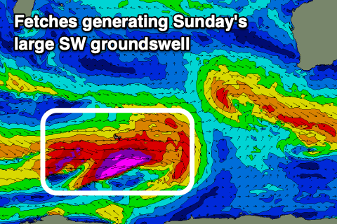
The reason for this is a polar frontal progression pushing up and towards the Bight on the weekend, preventing a high from fully moving in until next week. This will however generate a good large SW groundswell for Sunday which is a bonus.
Coming back to Saturday though and morning S/SE-SE winds are expected (possibly E/SE across the north end of the Cape) with Friday's easing W/SW groundswell, cleaner to the north ahead of afternoon S/SW breezes. Margs should see 8ft+ sets, 2-3ft in Mandurah and 2ft+ across Perth.
Sunday looks similar with S/SE winds across all locations (possibly S/SE-SE further north) and with the new long-period SW groundswell.
The bulk of this swell is being generated now by polar severe-gale to storm-force W/SW winds, but with the progression projecting north-east and maintaining strength, we'll see a large, consistent and good swell to 12ft+ across the South West, 4ft on the sets in Mandurah and 3ft across Perth.
A drop in size is likely through the afternoon with Monday still large but easing and with fresh E'ly offshore winds. We'll confirm all this again on Friday though.

