Fun tomorrow, large to extra-large swells to follow
Western Australia Surf Forecast by Craig Brokensha (issued Friday 10th July)
Best Days: Tomorrow, early Sunday and Monday Perth and Mandurah, early Wednesday and Thursday Perth and Mandurah
Recap
Good to great waves on the coast yesterday with a new building W/SW groundswell and local offshore winds, building from 6ft+ in the South West, 2-3ft in Mandurah and Perth. Winds remained good all day north of Margs, with burst of onshore winds with a squal in the South West.
Today the surf is pumping with clean 6-8ft waves across the South West, 3ft in Mandurah and 2-3ft across Perth. Winds will remain good all day as the swell likely drops a touch.
This weekend and next week (Jul 11 - 17)
With the first of the long-period W/SW groundswells coming in as forecast, we look to the next one that's due to peak through tomorrow. The forerunners may be seen later today but a peak is expected tomorrow with 6-8ft+ sets across the South West, 3ft in Mandurah and 2-3ft across Perth.
Winds will be favourable with a moderate to fresh E/NE breeze in the early morning, shifting more NE through the day and possibly easing a touch.
 Sunday looks poor with strong N/NE winds from dawn as Saturday's swell eases a touch, and winds shift NW into the afternoon. Perth and Mandurah will likely see NE winds at dawn favouring selected spots.
Later in the day another large new long-period W/SW groundswell is due, with it generated through this week by a significant fetch of severe-gale W/SW winds south-east of South Africa, then tracking east.
The swell should provide another significant kick in size with sets to 10-12ft across the South West, 3-4ft in Mandurah and 3ft across Perth. We'll see poor conditions across the South West with strengthening NW winds, lighter and more N/NE in Perth and Mandurah early.
Tuesday will then be poor everywhere as a vigorous polar front firing up around the Heard Island region tomorrow. A great fetch of severe-gale to storm-force W/SW winds will be projected towards us, with the stormy weakening on approach Tuesday, bringing a strong W/NW tending W/SW change.
The large, long-period W/SW groundswell is due to fill in Wednesday and peak around 12ft+ across the South West, 4ft in Mandurah and 3ft+ in Perth. Winds will unfortunately persist out of the NW, with a window of early N/NE winds further north around Perth and Mandurah, possibly similar Thursday as the swell eases.
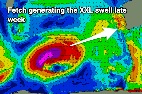
 Now, before this swell event gets a real chance to ease we'll see an even larger XXL long-period W/SW groundswell filling in, generated by an even stronger storm firing up close behind the one on the week.
A significant fetch of storm-force W/SW winds will be projected towards us, on top an active sea state, with the swell due to arrive on dark Thursday but peak Friday to 18-20ft+, 4-5ft in Mandurah and 3-4ft across Perth. Winds unfortunately look onshore out of the W/SW as the remnants of the storm move into us late week, easing next weekend as onshore winds slowly ease. More on this Monday though. Have a great weekend!


Comments
20s forerunners being picked up on Naturaliste..