Cleaner surf with fun amounts of size
Western Australia Surf Forecast by Craig Brokensha (issued Wednesday 1st July)
Best Days: Thursday, Friday, selected spots Saturday afternoon
Recap
Poor conditions across all locations yesterday with strong onshore winds and large to extra-large stormy waves on the coast. Today has remained poor across the South West and XL, while Mandurah and Perth were seeing improving conditions with surf to 4ft in the former and 3ft in the latter. This is a little under the expected 15-20ft, 4-5ft+ and 3-5ft respectively, though still very large and powerful.
This week and weekend (Jul 2 - 5)
With the severe low linked to today's large surf now pushing east through the Bight we should see winds continue to improve through tomorrow, swinging straight offshore out of the E across Perth and Mandurah with easing sets from 3ft and 3ft to occasionally 4ft respectively.
Margs should see more variable E/SE tending NE winds, becoming variable into the afternoon with easing surf from 8-10ft+.
 Friday looks great all day with moderate to fresh E/NE offshore winds, tending NE for a period but likely back to the E/NE late as the swell becomes smaller. The South West magnets will be the pick of the coast though back to 4-5ft or so, small and to 2ft in Mandurah, 1-2ft across Perth.
Our mix of long-range W/SW groundswell and closer-range SW swell are still due to build Saturday and hold Sunday, with the close-range swell now looking a bit better and bigger.
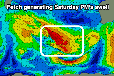
A broad and elongated fetch of strong to gale-force W/NW winds moving through our swell window will strengthen just before tracking south-east and out of our swell window, helping produce Saturday afternoon's kick in size.
We should now see the South West build to 5-6ft through the day Saturday, 2ft+ across Mandurah and 1-2ft in Perth, though strong N/NE tending N/NW winds will create poor conditions in the South West, better to the north and fresh NE tending lighter N.
Sunday looks similar in size across the South West, with Mandurah a touch better and to 2ft to possibly 3ft, 2ft on the sets in Perth. Winds will be average though and N/NE early in Perth and Mandurah, swinging N/NW into the afternoon, while Margs will see N/NW winds persisting all day.
The weekend's increasing northerly winds are ahead of a surface trough and the models diverge into early next week regarding where a low will form in the trough line.
 EC has it west of Margs resulting in onshore winds continuing Monday along with a new W/SW windswell as the northern flank of the low pushes into us. GFS has it off our South Coast resulting in S/SE tending S/SW winds Monday and no new swell.
Either way both models have onshore SW winds on Tuesday as the low pushes east, with Wednesday onwards seeing offshore winds kick back in and persisting through the rest of the week.
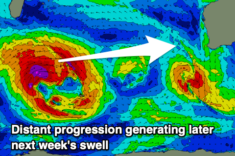
A good new long-period W/SW groundswell is on the cards as winds improve later week, generated by a good mid-latitude frontal progression developing under South Africa and pushing east while producing severe-gale W/SW winds, possibly reaching storm-force at times.
The swell will be inconsistent but large and long-period, arriving later Wednesday but peaking Thursday to 8ft+ across the South West, 2-3ft in Mandurah and 2ft+ across Perth. Following this there's plenty more activity on the cards, but more on this Friday.


Comments
Solid perfection Tuesday arvo. Makes up for the laydays. Got an urchin spike momento too.
Solid sets this AM, look closely right of the pine-tree a guy heading down the face, looks 3x overhead..