Large, easing surf as winds slowly improve
Western Australia Surf Forecast by Craig Brokensha (issued Wednesday 6th May)
Best Days: Perth and Mandurah tomorrow morning, the South West Sunday and Monday, all locations Tuesday
Recap
An early offshore across Perth and Mandurah with great waves on the former as a new W'ly swell provided 3ft surf and clean conditions. Margs was poor and onshore, while all coasts deteriorated rapidly through the day as winds strengthened and reached gale-force as a severe low moved in from the west.
The low has brought wide spread damage and some impressive wind and wave readings with Cape Naturaliste seeing gusts of 68kt (126km/h) yesterday evening, while the wave buoy peaked at 10m Significant Wave Height, Max Wave Height would be much bigger.
Rottnest Island peaked at over 8.5m Significant Wave Height but with strong to gale-force winds persisting today, surfing options are limited to novelty spots.

Satellite observation of the winds generated by the severe low.
This week and weekend (May 7 - 10)
The severe low linked to the large and stormy surf seen today is currently moving east while directing severe-gale to storm-force S/SW winds into the South Coast.
For the South West and metro regions though the main swell generating fetch is leaving us and we'll see the swell ease steadily through tomorrow out of the S/SW, though still large in the morning.
The South West should still see 8ft+ sets, 3ft in Perth and Mandurah but easing through the day.
A secondary front pushing up and into the South West will keep onshore winds blowing on the coast tomorrow, fresh to strong from the SW tending W/SW though more variable and light E'ly across Perth and Mandurah.
S/SE winds will then kick in across Perth and Mandurah on Friday but they'll be tiny and to 1-1.5ft or so, while Margs will see S'ly winds and easing sets from 4-5ft or so.
The weekend is looking much cleaner and better as a high moves in, swinging winds offshore out of the E/NE, variable into the afternoon.
A new mid-period S/SW swell should be seen across the South West from the front bringing onshore winds tomorrow. It only looks to be to 4-5ft with the rare bigger one across the South West and without much push, while Perth and Mandurah will remain tiny.
Sunday will be smaller as the swell eases with an offshore E/NE breeze ahead of weak sea breezes.
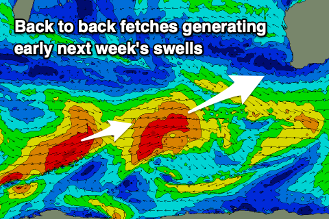
 Longer term our new W/SW groundswell for early next week is on track, with a strong and persistent low forecast to project a fetch of strong to gale-force W/SW winds from the south-east of South Africa, up north of Heard Island and then onwards towards us before dipping south-east on Sunday. This will then be followed closely by a secondary short-lived but strong front, producing a secondary reinforcing pulse of energy.
A moderate to large groundswell is due, building Tuesday and peaking into the late afternoon.
The South West should build to 6ft, with the possibility of sets to 8ft on the swell magnets, 2ft to occasionally 3ft in Mandurah and 2ft in Perth. As touched on also last update, winds will also be favourable and E/NE, tending variable into the afternoon, likely shifting onshore Wednesday. We'll have a closer look at this Friday though.

