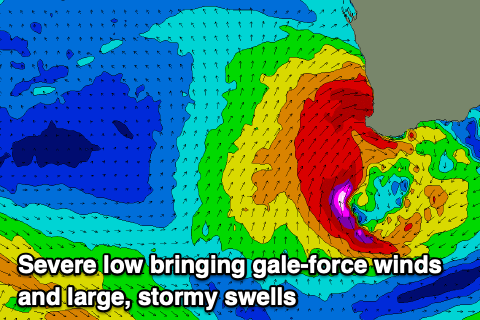
Batten down the hatches
Western Australia Surf Forecast by Craig Brokensha (issued Monday 4th May)
Best Days: Thursday morning Perth and Mandurah, Saturday in the South West, Sunday desperate surfers on the magnets in the South West, next Tuesday
Recap
Friday's large pulse of new W/SW and SW groundswell eased back into Saturday morning with inconsistent but clean 6-8ft sets across the South West, 2-3ft in Mandurah and 2ft across Perth.
A new W/SW groundswell started to fill in Sunday with the surf jumping to 3ft in Mandurah 2ft in Perth and 6ft across Margs though with the winds conditions were best in spots that handled the northerly as the swell continued to kick. It didn't look to reach the expected size into the afternoon unfortunately and this morning the swell is on the ease but with poor conditions.
This week and weekend (May 5 - 10)
A cold front currently pushing in and across us, bringing the rain and onshore winds will give way to a stronger mid-latitude system tomorrow, with it due to deepen significantly on approach towards us into the afternoon and evening.
This severe low will be cold, wet and very intense, even bringing snow to Bluff Knoll.
As the low approaches this we'll see N/NW winds strengthen and reach gale-force into the afternoon tomorrow, kicking up a stormy increase in NW windswell that'll reach 3-4ft+ across the metro beaches and Mandurah, larger across Margs.
 Behind this NW fetch will be severe-gale W/SW-S/SW winds aimed into the South Coast, bringing a large and stormy swell for Wednesday.
Mandurah and Perth look to come in at 4-6ft and 4-5ft respectively with the South West building to 10-12ft+ but with strong and easing W/SW tending SW winds.
Unfortunately another front approaching from the south-west will bring W/SW winds on Thursday, though Mandurah and Perth will see early variable offshores. The swell will be on a rapid easing trend though with 3ft sets around Perth and Mandurah, still 8ft+ or so across Margs.
The secondary front bringing Thursday's onshore winds isn't due to bring much in the way of new swell energy unfortunately with a mid-period S/SW swell due to build later Friday but peak Saturday.
The South West will see the most size with sets to 4-5ft+ or so and much better conditions as winds swing around to the E/NE (S/SE on Friday), while Perth and Mandurah are due to be tiny with the southerly swell direction.
Longer term we're likely to see a moderate to large sized SW swell early-mid next week, generated by a slow moving and not overly strong but persistent cold front pushing up and towards us. This should be met with offshore winds, but more on this Wednesday.
Also, as a final note, don't forget to tie down any loose ends with this coming storm.


Comments
Wow, imagine the swell generation/potential from early in that system and the impact in Bali, hope all the local crew are frothing too enjoy uncrowded perfection like the ye old days.
Whoa!! Hectic! Hoping a few of the novelty spots fire up on Wednesday.
Should give the banks a well needed re-modelling.
Hey Craig/Ben,
Do you guys have a link where you source the updated ASCAT satellite surface wind speeds from? NOAA website can be frustrating to navigate.
Cheers
Yeah, here ya go.. https://manati.star.nesdis.noaa.gov/datasets/ASCATData.php There are passes A/B/C
Beautyyy cheers moite
Just one more. Probably worth the sun stroke.
A great ASCAT image from early this morning. Looks like carnage with all the power outages this AM..
Was pretty nuts last night. About to go for a walk to check out the damage to the beach.
Was a wild old night....thought the roof was gonna blow off with a couple of those gusts in the early A.M
126km/h (68kt) gusts at Cape Nat, mental!
Wow. Wild figures.
9.39m swell at the moment, was bigger but buoy went offline during the peak
That would have to be on of the highest swell readings on that buoy UL, monstrous.
Edit : It appears it breached 11m about this time last night, lofty heights indeed.