A couple of swells to keep us entertained
Western Australia Surf Forecast by Craig Brokensha (issued Wednesday 8th April)
Best Days: Tomorrow morning, Friday morning, Tuesday and Wednesday mornings
Recap
Clean though windy conditions across the South West yesterday as our new inconsistent W/SW groundswell started to fill in, 4ft to so in the morning and reaching 6ft through the day as winds tending more northerly.
This morning the swell dropped back a touch to 4-5ft with early clean conditions but winds have since strengthened and swung more northerly. Perth and Mandurah built to 2ft on the sets yesterday, easing back from 1-2ft with clean conditions.

This week and weekend (Apr 9 - 12)
Local winds tomorrow are looking a touch better across the South West than forecast on Wednesday, and we've got a mix of new W/SW and SW swell filling in from a poorly aligned and structured low come trough that's currently breaking down well west of us. There'll also be some small minimal swell from Tropical Cyclone Irondro.
We should see the swell building through the day towards a peak into the afternoon with the South West reaching 4-6ft across the swell magnets, 2ft on the sets in Perth and Mandurah.
 A light morning N/NE-NE breeze is due across the South West, giving into a S/SE change as a trough moves through during the afternoon, so keep an eye on the local cams and observations when choosing where to surf. To the north conditions will be clean in the morning ahead of a S/SW change.
Friday should see SE winds across the South West as the swell eases back from 4-5ft, 1-2ft to the north with straighter morning E'ly winds ahead of sea breezes.
Moving into the weekend and there won't be much size left anywhere Saturday morning with a fresh E/NE offshore, shifting more N and then W'ly into the afternoon.
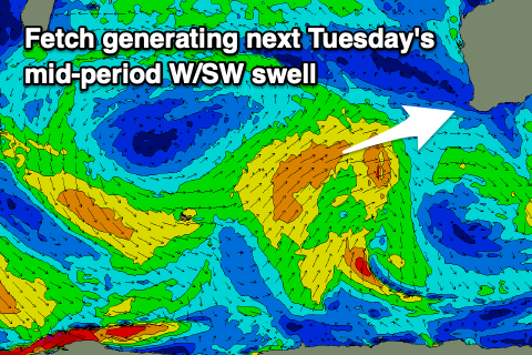
Longer term there's still nothing major on the cards for us with small background swells padding out the forecast ahead of a small mid-period W/SW-SW swell due Tuesday, followed by a stronger S/SW groundswell for Wednesday.
These swells will be produced by an initial weak mid-latitude front moving in from the west over the weekend, generating a fetch of strong W/SW winds, with a polar low forming at the base of the progression south-southwest of us due to generate a better fetch of gales in our southern swell window.
The W/SW swell should kick to a fun 2ft+ across Perth and Mandurah through the day Tuesday, 6ft across the South West, if not for the odd bigger cleanup with SE to SW winds.
The S/SW groundswell is due on Wednesday, building through the day and keeping the South West around 6ft on the sets, with Mandurah and Perth easing from 2ft.
Conditions are a little up in the air with the models divergent on the local winds, so check back here Friday for the latest.


Comments
Nice waves in North today. Great fun.
Great to hear, loving the north-easter eh?
Apparently the police have put up a sign with list of rules at a popular break. I will have to get a copy.
Look like today's swell over-performed a little in Mandurah and Perth. It could have been helped by swell from TC Irondro.
What's interesting is that the rain seen across the South West of the state is from the remnants of Irondro feeding into a surface trough..