Small run of swell continues
Western Australia Surf Forecast by Craig Brokensha (issued Friday 20th March)
Best Days: Sunday from late morning, Monday similar at swell magnets in the South West, Wednesday magnets in the South West
Recap
Improving surf with a drop in mid-period swell yesterday, 4-5ft across the South West, 2-3ft Mandurah and 2ft+ Perth.
This morning the swell is a bit smaller but still 4ft across the South West with decent conditions, tiny in Mandurah and Perth.
This weekend and next week (Mar 21 - 27)
There's been no real change to the coming days forecast with a new SW groundswell due to fill in this afternoon and ease a touch through tomorrow ahead of a secondary pulse later in the day, easing Sunday. These swells have been generated by late forming polar fronts in our southern swell window, focussing more towards Tasmania.
Size wise this afternoon's should push to 4ft+, easing back a touch from a similar size tomorrow morning in the South West.
The slightly stronger pulse of swell for the afternoon now looks to be around a similar size with no real additional swell due across the South West, with Sunday easing back from 4ft+ or so.
 Further north Mandurah and Perth will be tiny all weekend unfortunately.
Looking at the local winds and tomorrow, a less favourable and strong SE breeze is due across the South West possibly even S/SE early-mid morning, improving before reverting back to the S/SE into the afternoon.
Sunday looks windy but from the E/SE, with winds easing late morning, variable early-mid afternoon ahead of late sea breezes.
Into Monday a small mid-period pulse of swell should maintain 4ft sets in the South West as winds swing more offshore and out of the E/NE, variable into the mid-afternoon ahead of sea breezes.
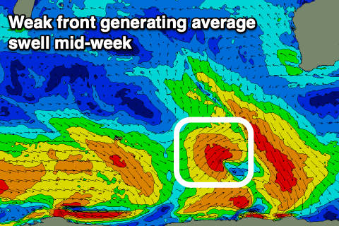
Unfortunately there's still nothing major on the cards for the rest of the week with the swell easing into Tuesday. Another weak polar frontal system should generate 3-4ft of swell for Wednesday, building through the day, tiny further north. Winds will start swinging more NE on Wednesday as a deepening mid-latitude low moves in from the west-southwest, but whether we'll see any swell from this system is up for grabs.
GFS says yes, ECMWF says no, so we'll have to keep an eye on it. More on this Monday. Have a great weekend!

