Southerly swells with stubborn winds
Western Australia Surf Forecast by Craig Brokensha (issued Wednesday 18th March)
Best Days: Tomorrow morning, Sunday later morning in the South West, Monday in the South West
Recap
Poor and onshore yesterday with small to tiny waves, building in size through the afternoon with strengthening winds, bigger today but a mess across most locations.
This week and weekend (Mar 19 - 27)
The current building swell energy is from a weak mid-latitude low pushing into us, but it should clear off to the east early tomorrow with improving winds across all locations with a weak, easing mid-period swell.
A light offshore E/SE-SE breeze is due tomorrow morning with easing sets from 4-5ft across the South West, 2ft Mandurah and 1-2ft Perth.
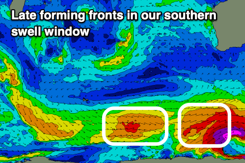
 Friday morning will then start smaller ahead of a small pulse of S/SW groundswell in the South West, generated by a late forming polar front in our swell window today.
A polar fetch of W/SW gales should kick up slight increase in size across the South West Friday afternoon to 4ft or so, tiny in Perth and Mandurah. Winds look better in the morning ahead of the swell with a fresh SE'ly, strong S/SE into the afternoon (not ideal).
Our stronger S/SW groundswell for the weekend is now looking a little suss with the low generating it forecast to be stronger, but developing later in our swell window, with a fetch of W/SW gales just firing up before pushing east.
This will limit the size and also the spots that will see the acute S'ly groundswell, with it due later Saturday but again only come in around 4-5ft on the magnets, easing from a similar size on Sunday.
Perth and Mandurah will remain tiny.
Winds are still looking an issue on the weekend, strong and out of the SE Saturday, similar Sunday early but easing and tending more E/SE later morning and early afternoon.
Another similar sized pulse of mid-period swell is due Monday but with weaker winds, offshore from the E/NE, variable into the mid-late afternoon.
Longer term there's nothing major on the cards unfortunately with a continuation of mid-period polar swell energy. More on this Friday though.

