Easing swell and wind over the weekend
Western Australia Surf Forecast by Craig Brokensha (issued Friday 1st November)
Best Days: Perth and Mandurah Sunday morning, South West Monday morning, protected spots Wednesday
Recap
Poor surf across all locations the past two days with strong to gale-force winds, cold and large, stormy surf.
This weekend and next week (Nov 2 - 8)
During the weekend we'll start to see the wind and weather abate, but conditions will remain poor across the South West both Saturday and Sunday, better in Mandurah and Perth Sunday morning.
The strongest of the frontal systems pushing up and into us is moving through today, with a peak in stormy swell due this afternoon, easing slowly through the weekend.
Fresh but easing SW winds are due tomorrow, with easing surf from the 8ft range across the South West, 3-4ft Mandurah and 3ft Perth.
Moderate SW winds will continue to create bumpy waves Sunday, lighter and more variable around Perth and Mandurah with easing 2ft+ and 2-3ft sets respectively.
Monday finally looks clean with a light E'ly offshore across the South West but there'll be little size left, with easing 3ft to maybe 4ft sets, tiny to the north.
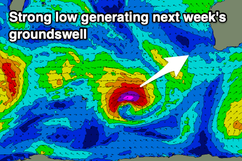
 We've got an upgrade in the swell due mid-week, with a tight and intense mid-latitude low that's forecast to develop north of the Heard Island region and generate a fetch of severe-gale to storm-force due to be longer lived. The low will be slow moving, generating a larger and long-period SW groundswell, while the remnants of the storm are due to project up towards us Tuesday, generating an additional mid-period swell.
These may at times on the sets not interact too well, but looking at the size and we should see the long-period swell arriving Tuesday afternoon, building later to 5-6ft or so in the South West but with onshore W/SW tending S/SW winds from the remnants of the swell generating storm clipping us.
Wednesday should see the peak and a bit cleaner (thought not ideal) conditions with sets to 6-8ft in the South West, 2ft to likely 3ft around Mandurah and 2ft in Perth with S tending S/SW winds (SE Perth and Mandurah).
We may see cleaner conditions as the swell eases into the end of the week but the models diverge on this. Longer term there's nothing too significant on the cards, but a long-range and inconsistent W/SW groundswell is due next weekend. More on this Monday. Have a great weekend!

