Smaller end to the week, large swells for next week
Western Australia Surf Forecast by Craig Brokensha (issued Wednesday 1st May)
Best Days: Margs tomorrow morning and northerly friendly breaks Friday morning, protected spots Tuesday and Wednesday next week
Recap
A large increase in W/SW swell yesterday to 8ft across the South West, best in protected spots, while Mandurah and Perth started clean and around 2ft+, bigger through the day.
This morning the swell has eased back to the 6ft range across the South West with improving conditions under a light offshore breeze, 2-3ft in Mandurah and 2ft in Perth.
Today’s Forecaster Notes are brought to you by Rip Curl
This week and weekend (May 2 – 5)
We'll see our current W/SW swell continuing to ease through tomorrow, but be good in the morning with an offshore E/NE breeze. It will be on the small size and dropping from 3ft+ in the South West, 1-1.5ft Mandurah and Perth.
A slight increase in long-range and inconsistent SW groundswell is expected on Friday but only to 3-4ft+ in the South West, tiny to the north and with E/NE-NE tending gusty N/NE winds, so hit those breaks that handle the northerly breezes.
 A shift in winds to a strong NW tending W/NW breeze Saturday will create poor conditions across all locations and bring an increase in mid-period and local W'ly windswell later in the day but more so Sunday.
Size wise we should see 2-3ft waves across Perth and Mandurah, with 4-5ft+ waves in the South West but with strengthening N/NW winds as a stronger frontal system nears in from the west.
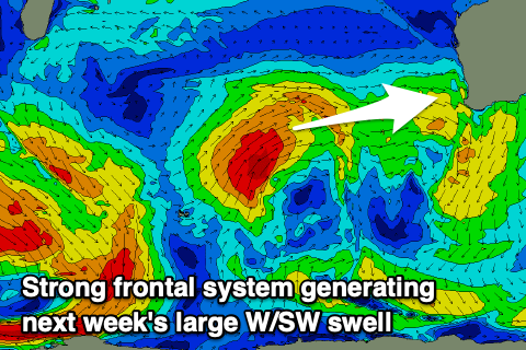
This storm will actually develop south-east of South Africa, with an initial fetch of W/SW gales forecast to slowly project east-northeast and then north-east up towards Indonesia through our western swell window.
The storm is due to break down to our west on Sunday, weakening to a trough and moving across us later Monday, followed by the swell on Tuesday.
Large surf out of the W/SW should be seen along with it being aimed more favourably towards the north of the state rather than south, but still Margs should peak around 8-10ft with 3-4ft waves in Mandurah and Perth.
Winds in the wake of the trough moving through Monday look average and out of the S/SW across all locations a touch better Wednesday and more from the S'th to possibly S/SE as the swell eases.
Thursday looks clean but the swell will be small by then. A new large long-range and long-period SW groundswell is likely to be seen later Thursday and Friday next week, generated by a significant storm developing south of South Africa and persisting through our swell window from this weekend into next week, but more on this Friday.

