Great, fun end to the week, large swell early next week
Western Australia Surf Forecast by Craig Brokensha (issued Wednesday 24th April)
Best Days: Thursday morning, Friday Margs and Mandurah, Tuesday morning Perth and Mandurah, Wednesday morning all locations
Recap
Excellent surf across the South West yesterday morning with large clean 6-8ft waves at dawn, building further through the day and best in protected spots with sea breezes. The swell built just ahead of sea breezes yesterday in Mandurah and Perth, best this morning with great clean conditions and easing 3ft and 2-3ft surf respectively. Margs pumped again with clean easing 6-8ft surf.
Today’s Forecaster Notes are brought to you by Rip Curl
This week and weekend (Apr 25 - 28)
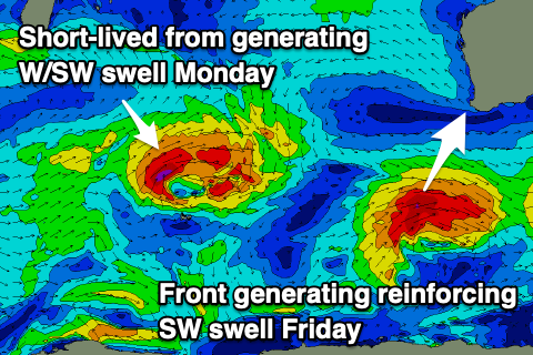
The end of the week will continue to offer excellent waves in the South West with the easing trend in swell slowed by some reinforcing SW swell from back to back fronts moving through our south-western swell window.
One of these will deepen significantly once east of our main swell window, generating large long-period groundswell to the south-east of the country, but coming back to our region and Margs should drop back from 5-6ft+ tomorrow, 2ft in Mandurah and Perth on the sets, easing further to 4-6ft Friday in the South West, 1-2ft in Mandurah and tiny in Perth.
 Winds tomorrow will be great again and offshore from the SE tending E/SE in the South West, and E/SE-E to the north ahead of sea breezes. Friday will then offer good clean conditions with an E/NE tending variable breeze.
Winds are expected to angle more N/NE on Saturday as the swell starts to drop more noticeably, favouring select locations in the South West.
Sunday will be poor with a low point in swell early and N/NE tending NW winds.
As touched on last update a good new W/SW groundswell is due early next week as a mid-latitude front develops north of the Heard Island region and projects a fetch of strong to gale-force W/SW winds towards us through our western swell window.
It's not expected to interact with a Tropical Cyclone Lorna in the Indian Ocean and instead continue moving slowly east while maintaining strength and passing under us Monday.
This should generate a large prolonged W/SW tending SW swell event, building later Monday and peaking Tuesday. Ahead of this a small W/SW swell from a more distant swell is due Sunday afternoon and Monday morning but with onshore SW winds.
Tuesday's expected size at this stage looks to come in around 10ft in the South West, 3ft in Mandurah and 2-3ft in Perth along with S/SW winds across the South West, more favourable and S/SE to the north.
Wednesday will clean up in the South West as the swell eases. More on this Friday though.

