Easing S swell followed by a large W/SW swell
Western Australia Surf Forecast by Craig Brokensha (issued Monday 8th April)
Best Days: The South West and Mandurah tomorrow, Friday all locations
Recap
Good waves across the South West magnets and small in Mandurah to kick off the weekend, while Sunday saw a large and powerful S/SW groundswell on the build. S/SE tending S/SW winds limited the best conditions to protected spots in the South West as the swell peaked, while this morning was much cleaner and good on the back side.
The South West was clean and easing from 8ft, with fun 2-3ft sets in Mandurah and 2ft waves in Perth.
Today’s Forecaster Notes are brought to you by Rip Curl
This week and weekend (Apr 9 - 14)
The surf will continue to drop through tomorrow, but a reinforcing S'ly groundswell should be seen in the South West, produced by a very late forming and final frontal system projecting up on the tail of the storm linked to yesterday and today's swell.
Magnets exposed to the south swell should see 6ft+ sets and with a great offshore E/NE wind, tending variable ahead of afternoon sea breezes. Mandurah should see inconsistent 2ft sets but at spots exposed to the south swell, not protected breaks, while Perth looks tiny and to 1-1.5ft.
 The swell will ease into the afternoon with not much left in the way of size Wednesday with easing 3-4ft sets across the South West. Unfortunately a surface trough will move through early morning bringing a SW change to most locations if not on dawn, shortly after, lingering from the W/NW into Thursday as a mid-latitude storm approaches from the west-southwest.
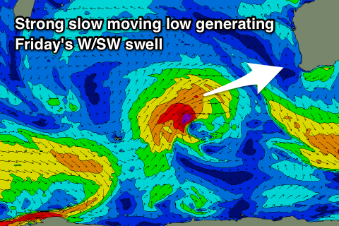
A large new W/SW groundswell is due off this storm as touched on last week, with it forming north-west of the Heard Island region today. A good fetch of strengthening and broadening strong to gale-force W/SW winds will be projected slowly towards us with a possible brief intensification of winds to severe-gale.
 A large consistent W/SW groundswell should fill in Friday and peak through the afternoon to 8ft across the South West, 3ft in Mandurah and 2-3ft in Perth with great offshore E/SE winds and afternoon SW sea breezes. Saturday will see easing surf but with onshore W'ly winds as an even stronger storm moves in.
This and a significant low moving into us later in the weekend and early next week will be a result of a node of the Long Wave Trough strengthening and becoming quite pronounced across us.
This will direct a series of strengthening storms up and into us, generating large to extra-large surf into early next week with onshore winds initially, possibly improving rapidly. We'll have a closer look at this Wednesday though.


Comments
Hi Craig
thanks for the ongoing education and predictions regarding swell for SW WA. So kinda question more than statement. The swell we had early this week arrived with a significant west in the direction rather than south as predicted. I'm basing this on the Naturalist swell buoy and my observations surfing on Monday at a location which clearly indicated west in the swell. My only other observation of interest that would be good to get your pitch on was that Monday with the longer duration the waves were certainly moving faster through the water. I know this is the case however interested at what point you think a noticeable difference in speed of swell occurs for surfers who are most familiar with 12 second duration.
cheers PK
Hey PK thanks for the observations. I'd say from where the storm was positioned that Sunday/Monday morning's swell would of been SW tending S/SW through the tail end of the event, with Tuesday seeing the more S'ly angled swell. The longer periods would of helped it refract into spots that usually require more west in the swell as you observed.
Compare where the weekend's swell generating storm was (first image).. to what's due this Friday, which is a true W/SW swell.
Re swell speed and noticeable difference. that's a tricky one. I'll tell you though in Sydney on the weekend the change of period from 8-9s to 14-15s dawn Sunday caught my sleepy self a little off. Had to paddle harder to get up to speed with the wave otherwise it'd pitch ya, so probably around that 15s mark.