Good to great waves from the weekend with large swells inbound
Western Australia Surf Forecast by Craig Brokensha (issued Wednesday 3rd April)
Best Days: Keen surfers Perth and Mandurah Friday morning, Saturday morning in the South West, all locations Sunday and Monday, the South West and Mandurah Tuesday morning
Recap
Fun and improving waves across the South West with 3-5ft of SW swell, tiny to the north around Mandurah and Perth.
The swell has dropped a touch into this morning though conditions were clean from the get go. A new long-period signal has boosted wave heights into this afternoon though with great 4-6ft surf across the South West. I didn't identify the source of this swell coming in cold off annual leave late last week, but it's an inconsistent and distant long-period source.
Today’s Forecaster Notes are brought to you by Rip Curl
This week and weekend (Apr 4 - 7)
Today's long-period groundswell has provided a touch more size this afternoon than expected with sets to 4-6ft and we'll see it dropping tomorrow from an inconsistent 4-5ft or so but with onshore SW winds as a polar front pushes up and into us.
This system is now forecast to move quicker than expected on Monday, with it forming into a mid-latitude low under the Bight, not off our coast.
This will see no major swell generated from it, with a weak mid-period S/SW swell easing from 4-5ft across the South West Friday morning, 2ft in Mandurah and 1-2ft in Perth. Winds are looking a little better though with a SE offshore in the South West and further north.
The longer-period energy from the earlier stages of the front is still expected to keep waves up around 4-5ft Saturday morning, easing through the day and tiny to the north.
 Winds look good again with a morning SE offshore, shifting S/SW into the afternoon.
Looking at our larger and stronger long-period groundswells from Sunday and the first is now looking to come in bigger than the second.
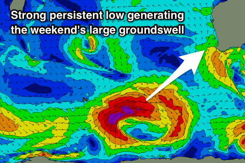
A strengthening and eastward tracking node of the Long Wave Trough will steer a series of vigorous polar storms through our southern swell window, the first forming around the Heard Island region today as a polar low.
This low should generate a great fetch of severe-gale to storm-force W/SW winds for a prolonged period of time while tracking slowly east. The low will then weaken while projecting slightly north-east towards our South Coast Friday evening and Saturday, generating a large long-period S/SW groundswell for Sunday.
Margs should reach an easy 10-12ft through the day, 2-3ft in Mandurah into the afternoon and likely also Perth. Winds are looking good and offshore out of the SE across Margs, more E/SE to the north and S/SE into the afternoon though gusty.
Monday looks great with a fresh and gusty E/SE offshore wind as the S/SW swell eases back from the 8ft or so in the South West.
The second swell will originate from a much more southerly direction as a stronger but late forming polar front projects a fetch of storm-force S/SW winds through our southern swell window.
This swell will make the most impact across the South West, with it arriving overnight Monday and peaking Tuesday morning to 8ft+. Winds look good again and offshore out of the E ahead of sea breezes, so all in all it's a great period from Saturday. Check back here Friday for any tweaking to the expected swells and winds.

