Average weekend better waves developing next week
Western Australia Surf Forecast by Craig Brokensha (issued Friday 8th February)
Best Days: Tuesday morning in the South West, Wednesday morning all locations
Recap
Poor conditions across the South West yesterday with strong cross-offshore winds and a smallish swell, much cleaner this morning and with some small OK waves on the magnets. Further north it's remained tiny and clean in the mornings.
Today’s Forecaster Notes are brought to you by Rip Curl
This week and weekend (Feb 7 - 10)
The weekend is looking average with the swell due to bottom right out leaving no real surfing options across the state.
Tomorrow will be nice and clean with a fresh and gusty E/SE offshore but little to no size left on the coast.
 Sunday morning will be even smaller and with less favourable S/SE-SE winds. Into the afternoon our new small mid-period SW swell is due to start building, peaking Monday.
The polar front linked to this swell wasn't special at all and we're only due to see sets to 3-4ft across the South West magnets, tiny in Mandurah and Perth. Winds will be an issue as well and out of the S/SE through the morning, onshore into the afternoon.
A new S/SW groundswell is due later in the day followed by a better increase through Tuesday afternoon, generated by late forming (in our swell window) but better aligned polar frontal activity over the weekend.
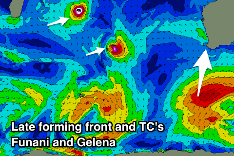
An initial strong fetch of S/SW winds will produce a small increase for later Monday and Tuesday morning, but a trailing fetch of gales projecting north-east should produce a better S/SW groundswell pulse for Tuesday afternoon, easing Wednesday.
Margs should build to a good 6ft through the afternoon while Mandurah will struggle to see size with the southerly swell direction, coming in at 2ft max on the sets, 1-1.5ft in Perth. Morning SE winds should create good conditions as the swell starts building across the South West, E on Wednesday morning as the swell eases from 4-6ft, 1-2ft and 1-1.5ft respectively.
Also in the mix on Tuesday/Wednesday will be a small and inconsistent long-period W/NW groundswell signal. This will be generated by Tropical Cyclone Funani which is sitting east of Madagascar. Funani and a secondary tropical cyclone Gelena will track south-east through our swell window, producing small pulses of W/NW groundswell.
Both look to offer no real size owing to the tight small fetches wrapping around the cyclones with inconsistent 1-2ft sets maybe in Perth and Mandurah Tuesday through Thursday, not noticeable in the South West.
Winds will deteriorate Thursday and swing S'th, better Friday and out of the SE but with minimal levels of swell.
Longer term there's nothing too significant on the cards, but more on this Monday. Have a great weekend!

