Mediocre surf continues
Western Australia Surf Forecast by Craig Brokensha (issued Monday 4th February)
Best Days: Sunday morning in the South West, Monday morning in the South West
Recap
An average start to the weekend with poor winds and a building swell, better yesterday with cleaner conditions and good easing sets from 4-5ft across the South West, 2ft in Mandurah and tiny in Perth.
This morning was cleanest as the swell continued to ease with fun 3-4ft sets on the magnets in the South West, 1-1.5ft in Mandurah and tiny in Perth.
Today’s Forecaster Notes are brought to you by Rip Curl
This week and weekend (Feb 5 - 10)
The surf will continue to ease over the coming days, with the downgrade in our reinforcing S/SW pulse for Tuesday being downgraded even further today. The weak front linked to it is even weaker, and no decent size is expected at all.
The South West should still offer 2ft+ sets tomorrow morning with an offshore E/NE breeze, tending variable ahead of afternoon sea breezes, while Wednesday looks average with winds out of the S/SE. Size wise Margs south swell magnets may see 3ft sets but with these winds conditions will be average.
 Mandurah and Perth are set to be tiny.
For the rest of the week the surf will remain on the small side. A weak and short-lived front that's currently north-east of Heard Island will generate the swell, though size wise we're only looking at small 3ft+ waves across Margs Thursday morning, tiny to the north.
Winds should improve and swing SE Thursday morning but with strength, creating tricky conditions, possibly a touch more onshore Friday but the surf will be small and fading.
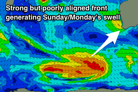
The next increase in noticeable swell is due over the weekend and namely Sunday, with a broad and strong but unfavourably aligned polar front due to skirt our swell window.
As a result we're only looking at building surf to 3-5ft or so across the South West magnets Sunday, 1-1.5ft in Mandurah and tiny in Perth. Morning SE winds will create good conditions with afternoon sea breezes, similar as the swell eases Monday.
Longer term there's still nothing of significance on the cards, though a tropical cyclone forming well east of Madagascar is expected to be absorbed into the westerly storm track, with a quick burst of W/SW gales due to be aimed through our western swell window. This will produce a small W/SW swell for mid-next week, but more on this Friday.

