Improving winds and easing swells
Western Australia Surf Forecast by Craig Brokensha (issued Monday 28th January)
Best Days: Protected spots tomorrow AM, Wednesday AM, Thursday AM South West magnets, protected spots Saturday PM and Sunday AM
Recap
Good fun waves Saturday in semi-protected spots with 4-5ft of groundswell leftover from Friday afternoon in the South West, and 1-2ft in Mandurah and Perth.
Sunday remained the same size but much cleaner, similar in Mandurah with tiny waves to the north.
Today we've seen a touch less size across all locations but with nice clean conditions again before sea breezes kicked in.
Today’s Forecaster Notes are brought to you by Rip Curl
This week and weekend (Jan 29 – Feb 3)
Our current run of S/SW swell will climax through tomorrow as a slightly stronger period pulse fills in, generated by the strongest but also not the most ideally aimed of the frontal systems moving through our swell window.
The swell is due to peak tomorrow morning and maintain 4-5ft sets across the South West, 1-2ft waves in Mandurah with tiny surf in Perth.
Winds will unfortunately have a S/SE tendency across most locations, better out of the SE on Wednesday (E/SE further north) but with easing sets from 3-5ft across south swell magnets in the South West. Mandurah looks to be tiny and to 1-1.5ft, 1ft in Perth.
 From here we'll continue to see the surf fading, with great offshore winds for magnets Thursday morning out of the E/NE, holding into the mid-afternoon and more NE Friday.
Looking at Tropical Cyclone Riley, and unfortunately there's no real sizeable swell due off this system at all, with it tracking unfavourably west-southwest across our swell window and also having no size to the fetch on its eastern flank. This will result in no considerable size across Perth above 1ft or so late week.
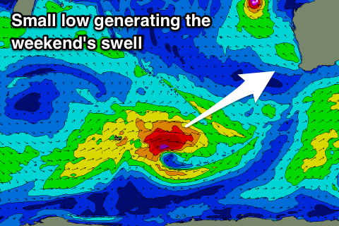
Into the weekend a new mid-period SW swell is due Saturday afternoon across the state, generated by a strengthening polar low just east of Heard Island Wednesday. A quick burst of slow moving W/SW gales will be produced, weakening but remaining strong while continuing through our swell window Friday.
No major size is expected off this low, but Margs should build to 4-6ft, with small 1-2ft sets in Mandurah and 1-1.5ft in Perth. Winds will be out of the S/SE, strengthening through the day and then better from the SE Sunday morning.
Beyond this there's nothing too significant on the cards but more on this Wednesday.


Comments
There no way last weekend was seeing 4-5ft. Beaches were 2-2.5ft all weekend with very average winds and a small window Sunday morning. Can we do something about the modelling for the SW? It seems to me to be consistently over calling swells.
Where for Cylinders?
We checked about 20 spots from Far Side of the Moon/3 Bears all the way down to South Beach/Contos. Yallingup, Moses/honeys, Cow Bay, Ellenbrook, MR/gas, Boodj, Redgate. Everything was struggling to even get shoulder high.
Cobbles was the only spot I saw something I would label 3ft and it was inconsistent at best.