Fun surf from Sunday
Western Australia Surf Forecast by Craig Brokensha (issued Friday 25th January)
Best Days: Saturday protected spots, Sunday morning, Monday morning, Tuesday morning protected spots
Recap
Easing choppy and stormy surf across all locations yesterday with a couple of OK options in protected spots. Today was cleaner but smaller across all locations with 1-2ft sets in Perth and Mandurah, bumpy and to 3-4ft in the South West (improving through the morning).
Today’s Forecaster Notes are brought to you by Rip Curl
This weekend and next week (Jan 26 – Feb 1)
A new long-period SW groundswell should currently be on the build across the South West, with it due to reach 6ft+ into the afternoon, 2ft+ in Mandurah and maintain 1-2ft sets in Perth.
Conditions will be average though with sea breezes, cleaner though still wind affected tomorrow as the swell eases. A moderate to fresh morning S/SE breeze is expected, more offshore to the north as the groundswell eases from 4-5ft+ across the South West 2ft on the sets in Mandurah and 1ft to maybe 2ft in Perth.
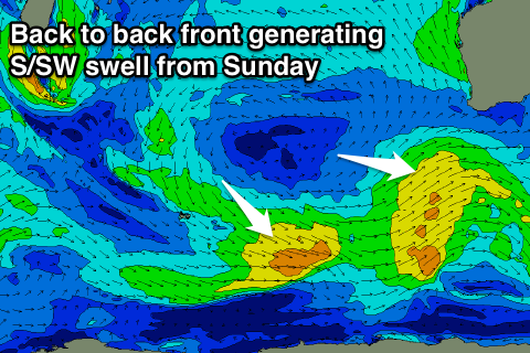
 From Sunday we'll see a run of cleaner waves and fun mid-period SW-S/SW swells as a series of back to back frontal systems fire up towards us and the move on to the Bight under the influence of the Long Wave Trough.
The first front will generate a fetch of strong SW winds and small mid-period increase in S/SW swell Sunday morning, while a secondary slightly stronger front should produce a touch more power late in the day and more so Monday morning.
Size wise we're looking at surf around 4-5ft, 1-2ft in Mandurah and 1-1.5ft in Perth, similar Monday morning. Another stronger front will form a little too late in our swell window Sunday and just maintain similar if not a touch bigger 4-6ft waves in Margs, 2ft in Mandurah and 1ft to maybe 2ft in Perth.
Winds on Sunday look great and offshore out of the E/SE across all locations, back to the SE Monday morning. Tuesday is looking a little dicier with S/SE breezes through the morning, similar and windier Wednesday.
Longer term there's no new swell really due until next weekend, with Tropical Cyclone Riley, which has formed north of Broome not expected to generate much in the way of swell at all.
It will track west-southwest and have no width to the fetch on its eastern flank (in our swell window) and be weak once moving into our swell window. As a result I wouldn't expect to see any noticeable swell from Riley at all. More on this Monday though, have a great weekend!

