Fading surf ahead of a strong new groundswell on the weekend
Western Australia Surf Forecast by Craig Brokensha (issued Wednesday 16th January)
Best Days: Margs swell magnets for desperate surfers Friday and Saturday mornings, protected spots Sunday afternoon in the South West and all spots Monday
Recap
Plenty of size continuing across the South West yesterday with a reinforcing mix of SW and W/SW swell though fresh S/SE winds limited the best waves to protected spots. Mandurah and Perth also provided good sets, cleanest early.
This morning both Perth and Mandurah were still fun though slightly wind affected and to 2ft, with easing workable 4-5ft waves across the South West.
Today’s Forecaster Notes are brought to you by Rip Curl
This week and weekend (Jan 17 – 20)
We've got a poor end to the week as the surf continues to drop and with onshore SW winds across the South West tomorrow, S/SE early in Perth and Mandurah but tiny.
Friday should be cleaner as winds go SE, but we'll only be looking at easing 2-3ft sets max across South West swell magnets.
The swell will bottom out on Saturday, though a very long-range and inconsistent long-period W/SW groundswell may provide the odd 3ft set in the South West as winds will go straight offshore out of the E ahead of afternoon sea breezes.
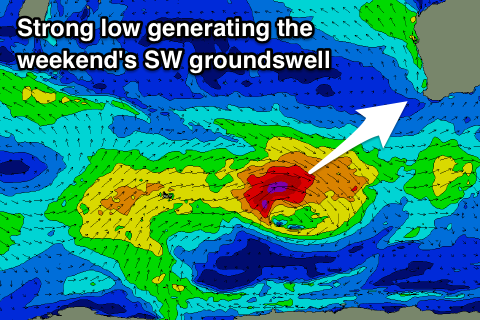
Our new long-period SW groundswell for Sunday is still on track, with a strong low expected to form north of the Heard Island region this evening, generating a tight fetch of severe-gale to storm-force W'ly winds.
 The low will track east-southeast while weakening slowly, passing under the state Friday evening.
A large long-period SW groundswell should be seen from this low, filling in Sunday and building rapidly to a peak into the afternoon. Margs is expected to offer 6-8ft surf, if not for the odd sneaky bigger bomb, with 2-3ft sets in Mandurah and 2ft in Perth, easing Monday from 6ft+ 2ft+ and 1-2ft respectively.
Winds are still looking average though, with a morning S//SE breeze, favouring protected locations, NE up around Perth and Mandurah. Winds will then swing onshore into the afternoon as the swell builds and a trough moves in from the west, leaving fresh and gusty S'ly winds into Monday.
Unfortunately S/SE winds look to persist through next week as the swell continues to ease, owing to a strong high stalling just to our west, being squeezed by fronts on its southern flank.
Some new S/SW groundswell should fill in later in the week and next weekend from the polar fronts, but more on this Wednesday.

