Fun weekend of waves, more swell next week but winds are an issue
Western Australia Surf Forecast by Craig Brokensha (issued Friday 28th December)
Best Days: Saturday morning, early Sunday, Monday mid-late morning and Tuesday morning in the South West
Recap
Average waves across all locations yesterday with no size to the north and onshore winds across the South West. Today the surf was poor again but some new swell is on the build though with no strength.
Today’s Forecaster Notes are brought to you by Rip Curl
This weekend and next week (Dec 29 – Jan 3)
The weekend is looking really fun with a strong front that's currently passing under us generating a good mid-period SW swell for tomorrow morning along with offshore winds.
The South West should see good 5-6ft waves tomorrow morning, with 2ft surf in Mandurah, 1-2ft in Perth, easing slowly through the day. Conditions look excellent across the South West and an E/SE offshore, possibly even tending E/NE for a period ahead of afternoon sea breezes, with morning SE winds to the north.
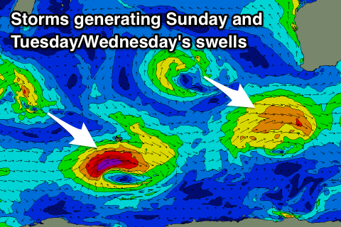
A secondary strengthening front south-west of us this evening, quickly moving off to the east will produce a reinforcing SW swell for Sunday to 4-5ft, if not for the rare bigger bomb, 2ft in Mandurah again and 1-1.5ft in Perth.
 Winds should be good and SE early, but a shift to the SW is expected sooner rather than later, so don't sleep in too long.
Winds Monday will be average at dawn but improve through the morning with a S/SE'ly tending E/SE through the day ahead of sea breezes with smaller easing surf from the 4ft range across the South West, 1-1.5ft in Mandurah and tiny in Perth.
Our longer-period SW swell for Tuesday is still on track, with a stronger low forming in the Heard Island region expected to produce a tight fetch of gale to severe-gale W/SW winds, weakening while projecting north-east towards us.
Mid-period energy will build ahead of the groundswell on Tuesday, with a peak likely overnight, easing Wednesday.
Margs should build to 6ft+ by dark Tuesday but with sea breezes, 2ft+ in Mandurah and and 1-2ft in Perth, easing back from 5-6ft, 2ft and 1-2ft respectively Wednesday.
Unfortunately an approaching trough looks to create average conditions Wednesday, bringing onshore W/SW winds.
This trough may form into a deep low pressure system off our coast, though the models diverge on this at the moment, so check back Friday for an update on later next week. Have a great weekend!

